
Volcan San Pedro is a climb of 6.0 kilometers (hors catégorie). Volcan San Pedro tops out at 2,140 m above sea level. It is located in n/a, Sololá, Guatemala. The average gradient is 9.2% with a maximum of 15.8%. The climb has 553 meters of elevation gain.
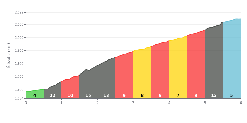
Difficulty breakdown: At 6 km with an average gradient of a brutal 9.2%, this climb is rated HC. The real crux is the middle section, especially between km 1.5 and 2.5, where the gradient hits 15% and then 12%. The finish is no picnic either, with 11% at 1 km to go, followed by an easier final section at 5%.
How to manage the effort:
1. Start controlled: The first 500m at 4% are your chance to find a rhythm without blowing up before the steep stuff.
2. Handling the middle section: Prepare for the hard stretch (km 1.5-2.5, 15% and 12%) by easing off a touch before you hit it, so you can hold a steady power output.
3. Save something for the finish: Despite a bit of relief between km 3.0 and 5.0, keep some in the tank for the final 11% ramp (km 5.0-5.5). That's where the time gets won or lost.
According to riders who have climbed it, the ascent of San Pedro volcano is a tough but magnificent climb, with about 1200 meters of elevation gain from the park entrance. The trail, well marked and shaded for most of the way, winds first through coffee plantations before entering dense forest. Riders describe a steady, steep gradient that really tests your legs, with the summit usually reached after 2:30 to 3:30 of effort.
The payoff is well worth it: once you punch through the clouds, the panoramic view over Lake Atitlán and the surrounding volcanoes is consistently described as "breathtaking" and "unforgettable." Riders stress the importance of setting off early in the morning to catch clear visibility before the clouds roll in and to avoid the rising heat.
Riders also bring up a safety concern that comes up often. While many recent reports mention a reassuring police presence around 2300 meters and say they had no problems, others recount armed robberies in the past. The general advice is to leave valuables behind and check the local situation at the time before setting out.
Access to the trail costs money (100 Quetzales for foreigners), and riders agree that a guide isn't necessary, since there's only one trail and it's well marked. The mood on the way up is often described as relaxed, with plenty of chances to pass other hikers and stop at the famous rope swing, a popular landmark along the climb.
6.0 km • 553 m D+
VAM: average climbing speed, based on elevation gain


Join thousands of cycling fans! Plan your rides, record your performance, track your progress and discover the finest climbs.
Live climb profile to pace your effort all the way to the top.


Within 20 km