
Maria Tecon is a climb of 11.3 kilometers (hors catégorie). Maria Tecon tops out at 3,050 m above sea level. It is located in Sololá, Sololá, Guatemala. The average gradient is 5.9% with a maximum of 12.8%. The climb has 668 meters of elevation gain.
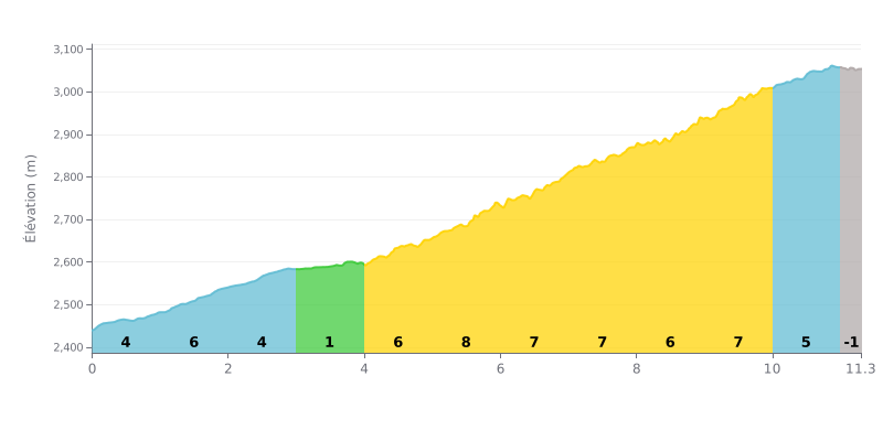
Difficulty analysis: This HC climb is genuinely hard because of its uneven profile. After 3 km of relatively moderate gradient, a very steep 4 km section (KM 5.0 to 9.0) with gradients between 6% and 8% forms the heart of the climb. The last part is more rolling (5%) before a slight descent to the finish.
Tips for the effort:
1. Pacing the middle section: Don't go out too hard. Save your legs for the toughest section (KM 5-9), where you'll need to hold a steady effort without blowing up.
2. Make the most of the breaks: The 1% kilometer (KM 3-4) is a crucial chance to recover and get your head and legs ready for the hard effort that follows.
3. Gearing: Anticipate the changes in gradient, especially the start of the 8% stretch. Run a gear that lets you keep a smooth cadence on the steepest ramps.
11.3 km • 668 m D+
VAM: average climbing speed, based on elevation gain


Join thousands of cycling fans! Plan your rides, record your performance, track your progress and discover the finest climbs.
Live climb profile to pace your effort all the way to the top.


Within 20 km