
Przełęcz Wyżniańska is a climb of 4.4 kilometers (category 4). The climb finishes at 853 m above sea level. It is located in gmina Lutowiska, województwo podkarpackie, Polska. The average gradient is 3.4% with a maximum of 8.5%. The climb has 149 meters of elevation gain.
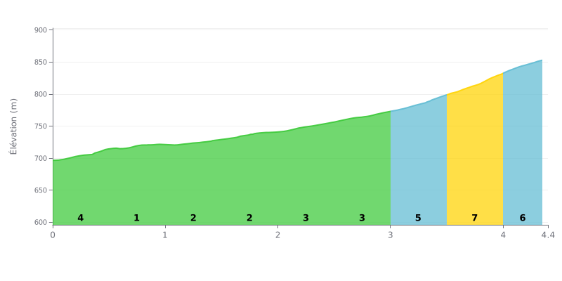
Difficulty analysis: With 4.4 km for 149 m of elevation gain and an average gradient of 3.4%, the Przełęcz Wyżniańska is a 4th category climb and a relatively approachable one. The first kilometers are gradual, with 4% from KM 0.0-0.5 and then only 1% from KM 0.5-1.0. The real difficulty comes at the end, between KM 3.0 and 4.4, where the gradients hit 5%, 7% and then 6%.
Tips for managing your effort:
1. Pace yourself from the bottom For the first 500 meters at 4%, settle into a steady rhythm and avoid going out too hard so you have something left in the tank for the finish.
2. Make the most of the flat-ish section The KM 0.5-1.0 stretch at 1% is your chance to recover, drink and eat something before the steeper ramps.
3. Handle the final with a small gear On the KM 3.5-4.0 section at 7%, shift to a gear you can spin comfortably, stay seated and keep a steady cadence all the way to the summit over the last 343 m from KM 4.0 to 4.4.
None of the reports covers the ride up. Those who did the Przełęcz Wyżniańska, a pass at 855 m with its big car park, set off on foot from the pass towards the Połonina Caryńska, the Mała Rawka or the Wielka Rawka. For most, the pass is mostly just a starting point.
The views come up again and again. You can see the Połonina Caryńska and the Wetlińska, and people say the summits are visible from every side. One person found the landscape stronger in the mist than in the photos. Along the trail there are benches to catch your breath, stone steps with a handrail on the steepest sections, and a bacówka near the Mała Rawka where you can eat and dry off. The bilberry pancakes at the refuge get a mention as very good.
The downsides are plenty. Parking costs between 15 and 30 zł depending on the year, and several people think that's too expensive. In season it fills up, so you need to get there early, before 6 h according to one person, or wait for a space. One person describes queues of cars stretching more than two kilometres back from Cisna at the turn-off for the car park. The surface is made of big stones, and low cars struggle to get over it. The toilets are sometimes closed, and the portaloos are poorly maintained. After rain the trail is slippery and muddy, and some gradients are tough. A man in charge of the car park is described as edgy with anyone without a ticket.
As for timings, take the signs with a pinch of salt. One sign says 1 h 30 for the Wielka Rawka, but one person took almost three hours. For the Połonina Caryńska, one group reckoned two hours with breaks, and one hour to come back down. Dogs can only come along for about 1.5 km, as far as the refuge below the Mała Rawka, because beyond that there are clear bans.
4.4 km • 149 m D+
VAM: average climbing speed, based on elevation gain


Join thousands of cycling fans! Plan your rides, record your performance, track your progress and discover the finest climbs.
Live climb profile to pace your effort all the way to the top.

