
Ondřejov is a climb of 13.8 kilometers (category 3). Ondřejov tops out at 638 m above sea level. It is located in Dlouhá Loučka, Střední Morava, Česko. The average gradient is 2.6% with a maximum of 9.3%. The climb has 361 meters of elevation gain.
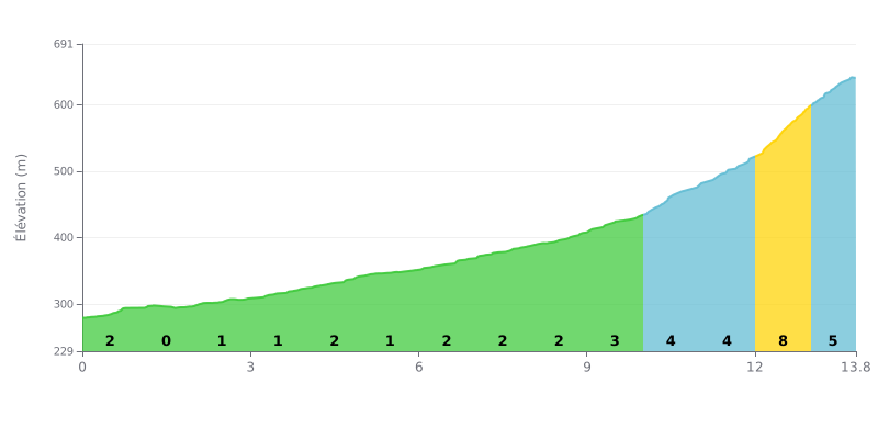
Difficulty breakdown: This 3rd category climb gets progressively harder. The first 10 km are moderate (average gradient of 1-2%), but the difficulty ramps up noticeably over the final 3.8 km, with an 8% section at the 12th km. The challenge lies in that tough finish after a long approach.
Pacing tips:
1. Managing your pace: Ride a steady, moderate tempo over the first two thirds to save your legs. Don't surge on the downhill false flats.
2. Saving something for the finale: Keep some energy in the tank for the last 4 km (gradients of 3% to 8%). Gradually step up your effort from km 10 onward.
3. Gearing: Pick a gear you can spin comfortably for the steep section between km 10 and 13.8 (5%, 4%, 8%). It's the key to getting up this climb.
13.8 km • 361 m D+
VAM: average climbing speed, based on elevation gain


Join thousands of cycling fans! Plan your rides, record your performance, track your progress and discover the finest climbs.
Live climb profile to pace your effort all the way to the top.

