
Skřítek is a climb of 9.1 kilometers (category 3). Skřítek tops out at 868 m above sea level. It is located in Rudoltice u Sobotína, Střední Morava, Česko. The average gradient is 4.0% with a maximum of 6.3%. The climb has 364 meters of elevation gain.
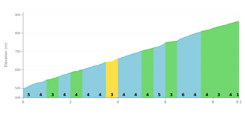
Difficulty analysis: This Category 3 climb is moderately hard. The average gradient of 4% over 9.1 km is steady, but the sector-by-sector breakdown shows two harder stretches: a 6% section around the 3.5 km mark and a longer 6% section between km 5.5 and 6.0. Km 6.0-6.5 gives you a brief breather at just 2%, before the final stretch settles back into a steady grade.
How to manage your effort:
1. Pace yourself on the first half: The gradient is consistent (3-4%). Don't go too hard, or you'll reach the two 6% ramps with nothing left in the tank.
2. Prepare for the two 6% ramps: Ease off slightly just before them (km 3.0-3.5 and 5.0-5.5) so you can tackle them at your own rhythm instead of getting caught out.
3. Make the most of the km 6 breather: The short descent at 2% is ideal for recovering and setting up the last 3 km, which are steady again at 4-5%.
9.1 km • 364 m D+
VAM: average climbing speed, based on elevation gain


Join thousands of cycling fans! Plan your rides, record your performance, track your progress and discover the finest climbs.
Live climb profile to pace your effort all the way to the top.

