
Alto La Paz is a climb of 9.9 kilometers (hors catégorie). The climb finishes at 1,581 m above sea level. It is located in Chinchiná, Caldas, Colombia. The average gradient is 5.2% with a maximum of 16.3%. The climb has 519 meters of elevation gain.
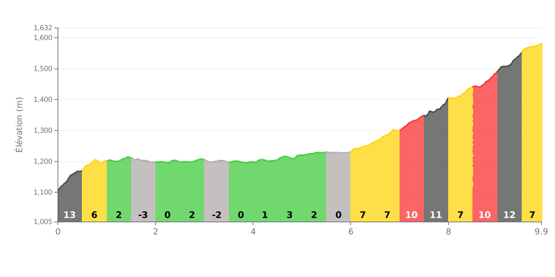
Difficulty breakdown: This hors catégorie climb packs 519 m of elevation gain over 9.9 km, for an average gradient of 5.2%. The start is the steepest, with 13% over the first 500 metres, then the road becomes more rolling up to km 6.0. The real test is in the final part, where the gradients bounce between 7% and 12% from km 6.0 to km 9.9, with no real respite. Those closing ramps, repeated one after another, will make the difference.
Pacing tips:
1. Don't go out too hard. Tackle the 13% from km 0.0-0.5 at a controlled pace so you have something left for later.
2. Recover on the flat sections. Use the 0% stretches (km 2.0-2.5, km 3.5-4.0 and km 5.5-6.0) to drink, fuel up and get your breathing back under control.
3. Save something for the finish. Take the 12% sections (km 7.5-8.0 and km 9.0-9.5) in an easy gear with a steady cadence.
9.9 km • 519 m D+
VAM: average climbing speed, based on elevation gain


Join thousands of cycling fans! Plan your rides, record your performance, track your progress and discover the finest climbs.
Live climb profile to pace your effort all the way to the top.

