
Alto La Paz is a climb of 2.6 kilometers (category 1). The climb finishes at 1,579 m above sea level. It is located in Chinchiná, Caldas, Colombia. The average gradient is 10.2% with a maximum of 20.2%. The climb has 267 meters of elevation gain.
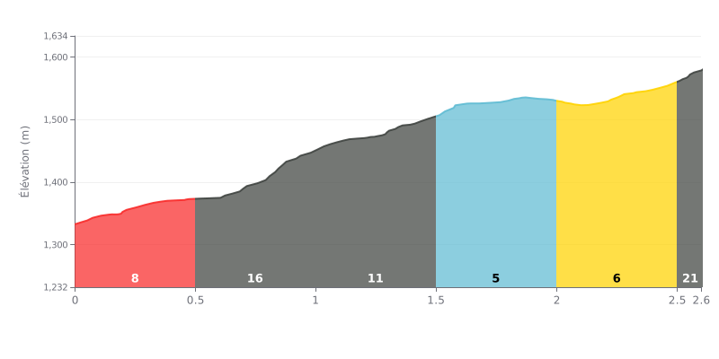
Difficulty breakdown: The Alto La Paz is a demanding climb: 2.6 km at an average gradient of 10.2% with 267 m of elevation gain, which earns it its Category 1 rating. The effort is hard from the bottom: 8% over the first 500 metres, then a very steep section at 16% between km 0.5 and 1.0 that starts to eat into your reserves. The stretch from km 1.5 to 2.0, at 4%, gives you a precious breather before a final ramp at 21% over the last 100 metres (km 2.5-2.6).
Pacing tips:
1. Save something for later Don't go too hard on the opening 8% so you hit the 16% section (km 0.5-1.0) with fresh legs.
2. Recover on the false flat Use the 4% section (km 1.5-2.0) to drink, take on fuel and settle back into a steady rhythm.
3. Manage the final ramp On the 21% section (km 2.5-2.6), keep a smooth cadence and controlled pedal strokes, because there are only 100 metres left to empty the tank.
2.6 km • 267 m D+
VAM: average climbing speed, based on elevation gain


Join thousands of cycling fans! Plan your rides, record your performance, track your progress and discover the finest climbs.
Live climb profile to pace your effort all the way to the top.

