
Odvracenica is a climb of 19.4 kilometers (hors catégorie). Odvracenica tops out at 1,596 m above sea level. It is located in Алуловиће, Централна Србија, Србија. The average gradient is 5.2% with a maximum of 15%. The climb has 1003 meters of elevation gain.
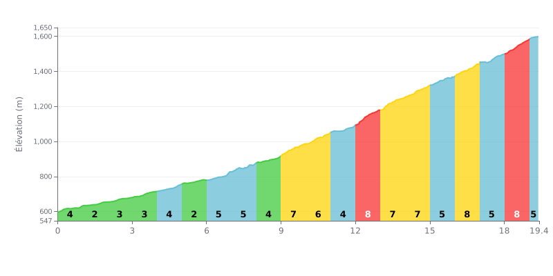
Difficulty breakdown: This 19.4 km climb gets progressively harder. The first half (KM 0-9) is moderate, with gradients of 2% to 5%, and works as a warm-up. Things ramp up significantly in the second half, with a tough stretch from KM 9 to 14 (gradients of 7% to 8%) and the final two kilometres at 8%, which makes for a brutal finish.
Pacing advice:
1. Manage your pace: Start easy over the first kilometres, which are less steep, to save your legs for the 7-8% sections.
2. Anticipate the hard sections: Mentally map out the critical stretches (KM 9-14 and KM 16-19) so you can adjust your effort and breathing as the steep pitches approach.
3. Keep a steady cadence: Use a gear that lets you hold a consistent cadence, especially on the 8% parts, to avoid burning out your legs too early.
19.4 km • 1003 m D+
VAM: average climbing speed, based on elevation gain


Join thousands of cycling fans! Plan your rides, record your performance, track your progress and discover the finest climbs.
Live climb profile to pace your effort all the way to the top.

