
Krće climb is a climb of 4.1 kilometers (category 1). Krće climb tops out at 1,176 m above sea level. It is located in Општина Сјеница, Централна Србија, Србија. The average gradient is 7.3% with a maximum of 15.7%. The climb has 296 meters of elevation gain.
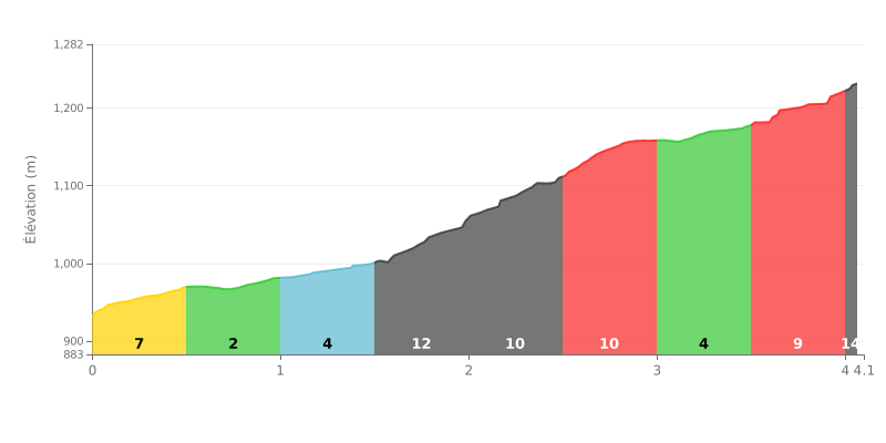
Difficulty breakdown: This Cat 1 climb has a very uneven profile. The real problem is a tough central section between KM 1.5 and 3.0, where the average gradient tops 10% over 1.5 km. The start and finish are more manageable, but the steepest kilometre (12%) demands disciplined pacing.
Tips for pacing the climb:
1. Managing your pace through the middle section: Plan for the hard stretch (KM 1.5-3.0). Settle into a steady, controlled rhythm from the bottom so you reach this section without already being over your limit.
2. Using the breaks: The 2% section (KM 0.5-1.0) and the 4% sections (KM 1.0-1.5 and 3.0-3.5) are chances to recover a little by easing off slightly, without slowing down sharply.
3. Staying focused in the final stretch: The gradient ramps back up to 9% over the last half kilometre. Keep some mental and physical reserve so you don't let up before the summit.
Climbers who have tackled the Via Ferrata Mučanj describe a varied and physically demanding route, especially in its first, near-vertical section rated D. Most of the route is fitted with metal gazištas, but some earth sections can get slippery when wet.
The climb is known for its breathtaking views, with a summit viewpoint that stretches out to the Durmitor and the Komovi on a clear day. One particularly memorable section is the huge vertical wall halfway up the route.
Riders' reports stress that you need to keep your wits about you on a few points: the signage for the access and the approach trail can be sparse, so a guide is handy the first time out. Also, the final stretch requires you to squeeze through a narrow cave, which isn't immediately obvious.
Despite these challenges, the experience is described as exceptionally rewarding, more technical and engaging than other similar routes. It suits adrenaline seekers looking for a real thrill, but is not recommended for beginners.
4.1 km • 296 m D+
VAM: average climbing speed, based on elevation gain


Join thousands of cycling fans! Plan your rides, record your performance, track your progress and discover the finest climbs.
Live climb profile to pace your effort all the way to the top.


Within 20 km