
Golija climb is a climb of 13.0 kilometers (hors catégorie). Golija climb tops out at 1,417 m above sea level. It is located in Општина Ивањица, Централна Србија, Србија. The average gradient is 6.6% with a maximum of 15.1%. The climb has 858 meters of elevation gain.
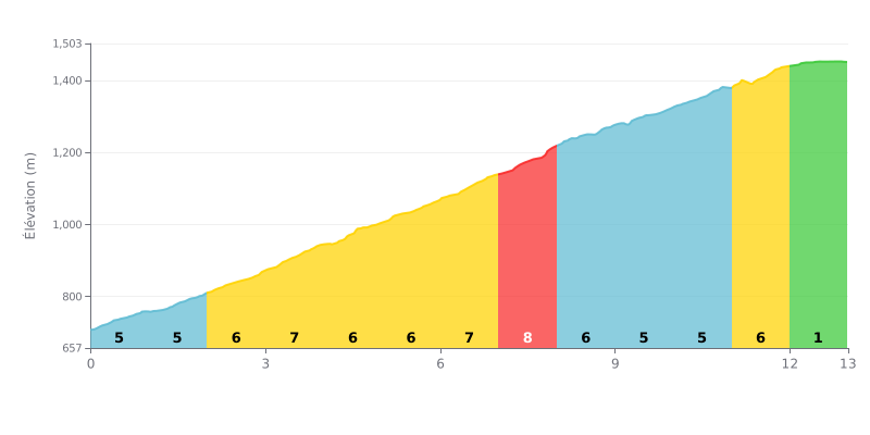
Difficulty analysis: This 13 km HC climb has a sustained average gradient of 6.6%, but its difficulty lies in how the gradient progresses. The slope rises steadily to a peak of 8% between km 7 and 8, just before a brief easing. The final kilometer is almost flat (1%), which pulls the average gradient down.
Pacing advice:
1. Start conservatively: The first kilometers (5-6%) are relatively gentle. Use them to settle into a steady rhythm without burning your legs too early.
2. Prepare for the heart of the climb: Get ready mentally and physically for a hard stretch between km 3 and 8, where the gradient hovers between 7% and 8%. This is where the effort will be most intense.
3. Save something for the finish: Don't let up after the km 8 peak. The 5-6% ramps that follow still demand a steady cadence before the final respite on the last kilometer.
13.0 km • 858 m D+
VAM: average climbing speed, based on elevation gain


Join thousands of cycling fans! Plan your rides, record your performance, track your progress and discover the finest climbs.
Live climb profile to pace your effort all the way to the top.


Other climbs to Golija climb