
Metsad Tamar is a climb of 16.9 kilometers (category 1). Metsad Tamar tops out at 398 m above sea level. It is located in מועצה אזורית תמר, מחוז הדרום, ישראל. The average gradient is 2.4% with a maximum of 13.7%. The climb has 403 meters of elevation gain.
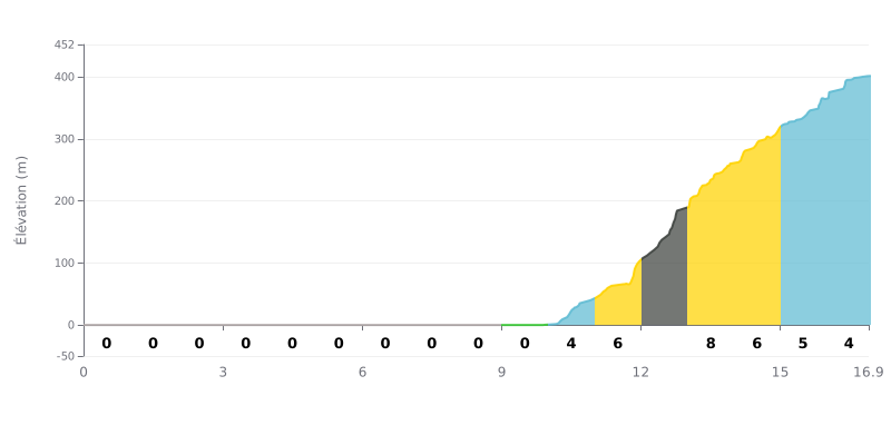
Difficulty analysis: This climb has an unusual profile: 10 km of completely flat road followed by 7 km of continuous climbing. The difficulty lies in that sudden change of rhythm and in the concentration of 403m of elevation gain over a short distance, with gradients up to 8%. Category 1 is justified by the intensity of the steep section.
Pacing advice:
1. Save your legs on the flat: Use the first 10 km to ride in a group and sit in the wind, without going over your limit. The goal is to reach the climb with plenty left in the tank.
2. Start the climb steady: Don't get carried away by the excitement at the foot of the ramp (4%). Find a rhythm you can hold through the 6-8% sections so you don't blow up early.
3. Be ready for the gradient change: The hardest part comes between km 12 and 13 (8%). Keep some power in reserve so you can get over this key section without losing your rhythm.
For cyclists riding the Israel Trail, the climb up to Mezad Tamar is a direct immersion in history. Riders describe discovering the imposing ruins of a Romano-Byzantine fortress dating from the 3rd century, a strategic outpost on the old trade route. Unfortunately, the experience is often soured by disappointment, as riders find the site neglected, dirty, and badly lacking in information panels, which gives the impression of an abandoned place.
The atmosphere around Mezad Tamar is marked by a striking duality. On one side, the silent desert and the grand scenery, with views over the Dead Sea, make for a magnificent setting for a break. On the other, the immediate proximity of the busy Route 25 and an active quarry often shatters that calm. Riders report constant noise from trucks, even at night, and crushing operations that start early in the morning, spoiling the serenity of the spot.
As a stopover, the site is seen as a basic, wild campsite. Riders appreciate the space available and the chance to shelter from the wind in the abandoned buildings nearby. However, they point out the total lack of amenities: no water, no lighting, no bins. Caution is needed when parking your bikes because of the many nails on the ground, and it is not advisable to leave belongings unattended.
Despite its drawbacks, the experience remains memorable for those who love history and desert landscapes. Riders recommend stopping for a short visit in the late afternoon, enjoying the sunset and the stars, and considering a hike to the next water point, Ein Zafit. It is an authentic and rustic stage that requires making do with the elements, but it offers a real change of scene on the way to Eilat or the Dead Sea.
16.9 km • 403 m D+
VAM: average climbing speed, based on elevation gain


Join thousands of cycling fans! Plan your rides, record your performance, track your progress and discover the finest climbs.
Live climb profile to pace your effort all the way to the top.


Within 20 km