
Ma'ale Efraim is a climb of 9.3 kilometers (category 3). Ma'ale Efraim tops out at 191 m above sea level. It is located in מועצה אזורית ערבות הירדן, יהודה ושומרון, Palestinian Territory. The average gradient is 2.1% with a maximum of 11.2%. The climb has 195 meters of elevation gain.
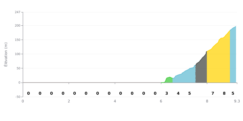
Difficulty breakdown: This Category 3 climb is quite unusual. The first 6 kilometres are dead flat (0% gradient), so all 195m of climbing is packed into the last 3.3 kilometres. The real difficulty is short but punchy, with an average gradient of nearly 6% over the final section, including stretches at 8-9%.
How to manage the effort:
1. Pacing: Use the first 6 km to spin along in Z2 without hammering, and warm up properly. The climb doesn't really start until km 6.
2. Anticipate the change of rhythm: From km 6 on, get your gear and cadence sorted before the ramps kick up (3%, then 5%, then 8-9%).
3. Split your effort: Since the hard part is short, you can hold a strong but controlled effort and avoid blowing up in the steepest sections (km 7.5 to 8.5).
9.3 km • 195 m D+
VAM: average climbing speed, based on elevation gain


Join thousands of cycling fans! Plan your rides, record your performance, track your progress and discover the finest climbs.
Live climb profile to pace your effort all the way to the top.


Within 20 km