
Gardaneh Ye Tash is a climb of 49.6 kilometers (hors catégorie). Gardaneh Ye Tash tops out at 2,953 m above sea level. It is located in دهستان میان بند, استان مازندران, ایران. The average gradient is 7.4% with a maximum of 20.9%. The climb has 3685 meters of elevation gain.
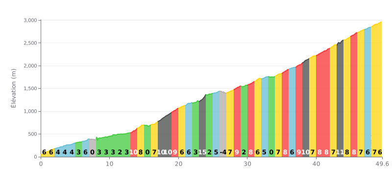
Difficulty analysis: This 49.6 km climb is a pure endurance test. The average gradient of 7.4% is steep, but the main challenge lies in its length and uneven profile. The first part is fairly moderate (KM 0-13, gradient mostly under 5%), followed by a very demanding central section (KM 13-23) with gradients around 10% and a brutal spike to 15% at KM 23. The final stretch (KM 37-44) features another series of 10-12% ramps, which makes it a real tactical challenge.
Pacing advice:
1. Managing your pace over the distance: Resist the urge to push hard in the opening kilometres, which are relatively easy. The goal is to save your legs for the steep sections in the middle and at the end.
2. Anticipating gradient changes: Kilometre 26 has a short descent (-4%). Use it to recover actively (spin the legs easily) before the next climbing section.
3. Breaking the climb down: Don't think about the 49 km all at once. Focus on getting over the three main "walls": the 15% spike (KM 23), the 10-12% section (KM 37-44), and then the final drag to the top.
49.6 km • 3685 m D+
VAM: average climbing speed, based on elevation gain


Join thousands of cycling fans! Plan your rides, record your performance, track your progress and discover the finest climbs.
Live climb profile to pace your effort all the way to the top.

