
Kodir is a climb of 29.8 kilometers (hors catégorie). Kodir tops out at 1,701 m above sea level. It is located in دهستان میان بند, استان مازندران, ایران. The average gradient is 6.9% with a maximum of 17.6%. The climb has 2054 meters of elevation gain.
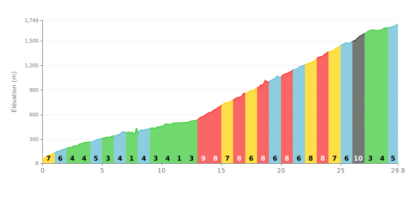
Difficulty breakdown: This HC climb is 29.8 km long with 2054m of elevation gain, so it's a serious undertaking, both for the vertical and the distance. The main challenge is how uneven it is. After a fairly moderate first section, the central part (KM 13 to 26) is brutal, with sustained gradients of 7% to 9%. The steepest kilometre is at 9% (KM 26.0-27.0). A notable breather at 0% between KM 7.0 and 8.0 is worth saving your legs for.
Tips for managing the effort:
1. Pacing: Start easy and keep something in the tank. The real effort begins after the flat section at the 7th km, so mentally prepare for the 13 km crux between KM 13 and 26.
2. Anticipate the gradient changes: Use the easier stretches (KM 5-7, KM 11) to recover and ease the pressure on your legs before the 8-9% sections.
3. Plan your fueling: On a climb this long, you need a disciplined approach to hydration and nutrition, especially in the first half before the steepest sections hit.
29.8 km • 2054 m D+
VAM: average climbing speed, based on elevation gain


Join thousands of cycling fans! Plan your rides, record your performance, track your progress and discover the finest climbs.
Live climb profile to pace your effort all the way to the top.

