
Gulmarg is a climb of 22.7 kilometers (hors catégorie). Gulmarg tops out at 2,728 m above sea level. It is located in Wagura, Jammu and Kashmir, India. The average gradient is 5.4% with a maximum of 14.4%. The climb has 1221 meters of elevation gain.
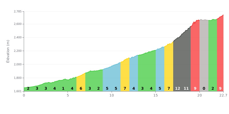
Difficulty analysis: This 22.7 km climb (HC) has two distinct parts. The first 17 km, averaging around 4%, make up a long, demanding approach. The real difficulty starts in the last 5 km, with a brutal sequence of 12%, 11%, then 9%, packing a lot of elevation gain into a short distance after a long warm-up.
Tips for managing the effort:
1. Pacing: Resist the urge to attack in the first 17 km. Use this section to find a steady, energy-efficient rhythm, because the real suffering comes later.
2. Prepare for the final wall: Save some legs and some head space for km 17 to 20, where the gradient goes over 10%. Having the right gearing for this section is crucial.
3. Recovery on the flat: Km 20-21 (0% gradient) gives you a short window to recover a bit before the final 9% ramp. Make the most of it to eat and drink, and briefly ease the pressure on your legs.
22.7 km • 1221 m D+
VAM: average climbing speed, based on elevation gain


Join thousands of cycling fans! Plan your rides, record your performance, track your progress and discover the finest climbs.
Live climb profile to pace your effort all the way to the top.

