
Vijlenerbos is a climb of 5.3 kilometers (category 3). The climb finishes at 273 m above sea level. It is located in Vijlen, Limburg, Nederland. The average gradient is 3.0% with a maximum of 8.4%. The climb has 159 meters of elevation gain.
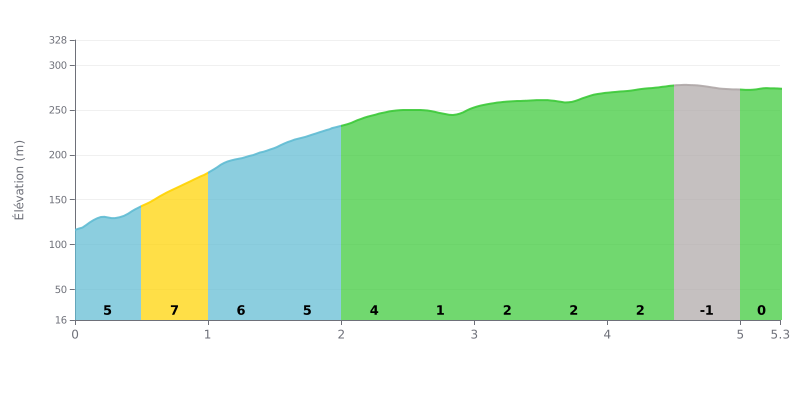
Difficulty analysis: This 5.3 km climb with 159 m of elevation gain averages 3% and is rated Category 3. The difficulty is concentrated in the first two kilometres, with 5% and then 8% between 0.5 and 1.0 km, which demands a committed start. After that, the road becomes more rolling, with gradients of 1% to 2% between 2.5 and 4.5 km, before a short false flat downhill and a final flat section.
Tips for managing your effort:
1. Pace the start. Don't go out too hard on the 8% section between 0.5 and 1.0 km, and settle into a steady rhythm from the first few hundred metres.
2. Recover on the rolling section. Between 2.5 and 4.5 km, the 1% to 2% gradients give you the chance to catch your breath and gradually build back up.
3. Finish smoothly. Use the -1% stretch between 4.5 and 5.0 km to recover, then hold a steady cadence on the final flat section all the way to the finish.
Those who have been to the Grafheuvel mostly describe a quiet wood, with plenty of birds, wide tracks and several marked trails. Several people find the views lovely during the ride.
The site is a child's grave dating from around 1000 BC, known for a bronze statuette that many people mention. An information board explains the site. Some find it interesting, others say it lacks context. One person adds that without the excavations, you would only recognise these mounds on the Actueel Hoogtebestand, the relief map of the Netherlands.
On the downside, the vegetation is a nuisance. Several people say the moss, leaves and brambles hide the mound and make it hard to see the layers shown on the board. Another finds the site underwhelming. The little café, where you could once grab a meal or a coffee with a view, is closed now. One rider also notes that the spot is close to the main road, even if it stays calm.
For history or nature lovers, the site is worth the detour, as long as you come knowing you'll need a bit of imagination to see the graves and that the vegetation can spoil the view.
5.3 km • 159 m D+
VAM: average climbing speed, based on elevation gain


Join thousands of cycling fans! Plan your rides, record your performance, track your progress and discover the finest climbs.
Live climb profile to pace your effort all the way to the top.


Within 20 km