
Vaalserberg is a climb of 5.7 kilometers (category 3). The climb finishes at 321 m above sea level. It is located in Gemmenich, Liège, België / Belgique / Belgien. The average gradient is 3.2% with a maximum of 6.8%. The climb has 185 meters of elevation gain.
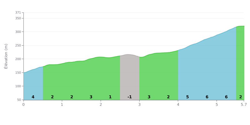
Difficulty breakdown: The Vaalserberg from Volkerich is a 3rd category climb covering 5.7 km with 185 m of elevation gain and an average gradient of 3.2%, which makes it very doable for a regular rider. The real work is in the final section: between km 4.0 and 5.5, the road ramps up to 6% over 1.5 km, after a rolling first half. The opening 500 m at 4% does demand a steady rhythm from the start, though.
Tips for managing your effort:
1. Pace yourself from the bottom Don't go out too hard in the first 500 m at 4%. Keep a steady cadence so you reach km 4 with legs still fresh.
2. Recover on the rolling section Use the km 0.5 to 4.0 stretch, where the gradient stays between -1% and 3%, to top up your energy and drink.
3. Handle the 6% ramp Between km 4.0 and 5.5, drop into an easier gear, stay seated if needed, and keep a smooth cadence all the way to km 5.7.
Few reviews talk about the climb itself, most coming from walkers and families. Those who rode up on a bike find it harder than it looks: one calls it a "flinke beuker", a proper hill, and recommends a solid base fitness. Another rates the climb from the Belgian side as nicer than the Dutch side. One cyclist describes it as a lovely climb, served by several cycling and walking routes.
The summit, at around 322 meters, is the highest point in the Netherlands on the mainland. Many say the spot has nothing spectacular about it, and that it's mainly worth the visit for the tri-point marker where the Netherlands, Belgium and Germany meet. The observation tower gives a view over all three countries and the surrounding countryside. There are also forest trails, a hedge maze, a playground and a few restaurants, which families appreciate.
The negatives come up often. Cars pass within a few meters of the marker; one visitor counted five in ten minutes and worried about the kids. The tower lift is sometimes out of order, and the opening hours on the website don't always match reality: one visitor turned up at 11 a.m. to find neither the tower nor the maze open. In summer, everything shuts around 6 p.m. The toilets were closed during one of the visits. Several find the place too commercial, with a funfair at the top and prices that feel high, and one notes that online maps sometimes place the summit in Belgium.
For access, you can drive right to the top, where there are several car parks. From Germany, a bus gets you to the area, but one visitor took more than an hour to walk from the German-side stop. Trails can get muddy in wet weather, and in winter there may be snow when it has already melted elsewhere in the Netherlands. Reviewers recommend bringing good shoes.
5.7 km • 185 m D+
VAM: average climbing speed, based on elevation gain


Join thousands of cycling fans! Plan your rides, record your performance, track your progress and discover the finest climbs.
Live climb profile to pace your effort all the way to the top.

