
Cliff cyclamen is a climb of 3.3 kilometers (category 3). Cliff cyclamen tops out at 503 m above sea level. It is located in Vallée de Beït-Shéan, מחוז הצפון, ישראל. The average gradient is 4.5% with a maximum of 12.5%. The climb has 151 meters of elevation gain.
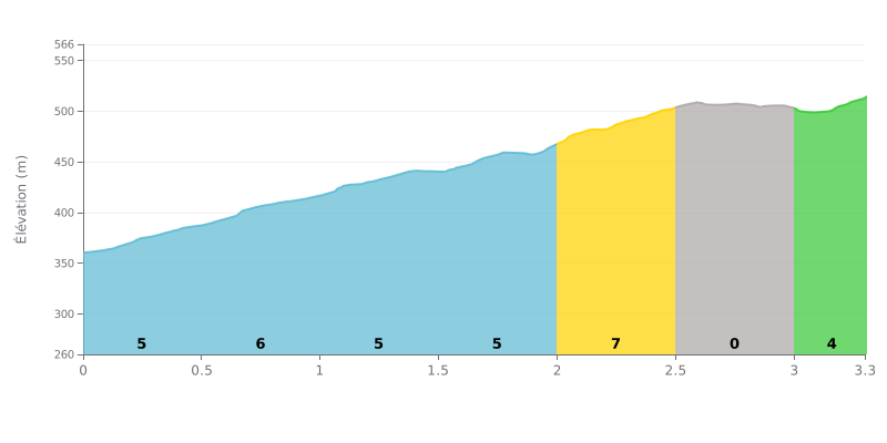
Difficulty analysis: This 3.3 km climb with 151 m of elevation gain averages 4.5%, which puts it in category 3. The hard part is concentrated between km 0.0 and 2.5, where the gradient stays steady between 5% and 6%, then ramps up to 7% between km 2.0 and 2.5. The almost flat stretch from km 2.5 to 3.0 gives you a short breather before the final section at 4% from km 3.0 to 3.3. With no truly steep pitch, it's mostly the length of the effort at a sustained pace that will make the difference.
Tips for the effort:
1. Find a steady rhythm from the bottom. In the first kilometers at 5%, don't go out too hard so you keep some reserves for the 7% section between km 2.0 and 2.5.
2. Make the most of the flat. On the nearly flat stretch from km 2.5 to 3.0, ease off the pedals a little, catch your breath and get your head ready for the last push.
3. Pace the finish. Over the last 300 meters at 4%, gradually build your cadence and stay seated if you can to keep some power until the top.
For riders tackling Cliff Cyclamen, the climb is inseparable from the spectacular wildflower display, especially in early spring. Riders describe a road "full of irises" and a "riot of colour" in March, with the Gilboa iris as the highlight, described as "stunning and huge". Some riders say the ideal window for this show is between March and April.
Beyond the flowers, riders are unanimous about the scenery. The climb offers a "magnificent viewpoint" and a "breathtaking panorama" over the region. The atmosphere is often described as peaceful, a "quiet" spot where you can "recharge your batteries" in the middle of nature. The route is reported as "very rideable" and "loop-shaped", which makes it accessible.
However, riders warn that the experience depends heavily on the season. One cyclist went out "looking for flowers" and found none, which turned out to be "very disappointing". Others mention that to really enjoy it, you need to plan a half-hour walk from the road to reach a waterfall or a spring, a detour not everyone is willing to make.
The climb seems well suited to family or leisure riding, with "flat sections perfect for picnics". The overall impression left by riders is of a "unique" and "enchanting" place, a nature escape that, at the right time of year, is a real "fountain of youth" for the senses.
3.3 km • 151 m D+
VAM: average climbing speed, based on elevation gain


Join thousands of cycling fans! Plan your rides, record your performance, track your progress and discover the finest climbs.
Live climb profile to pace your effort all the way to the top.


Other climbs to Cliff cyclamen