
Mount Barkan is a climb of 11.0 kilometers (category 1). Mount Barkan tops out at 461 m above sea level. It is located in מועצה אזורית גלבוע, מחוז הצפון, ישראל. The average gradient is 4.5% with a maximum of 10.7%. The climb has 490 meters of elevation gain.
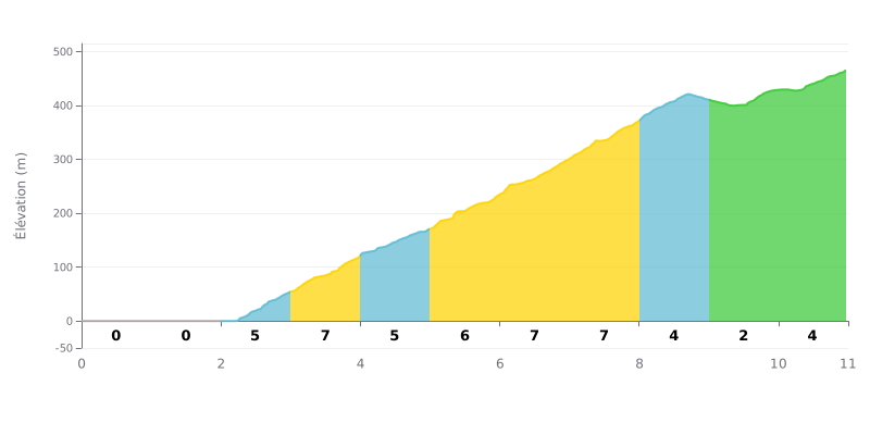
Difficulty breakdown: This Cat 1 climb has a deceptive profile. The first 2 km are flat, followed by a brutal 5 km central section (KM 3.0 to 8.0) with steady gradients between 5% and 7%. The difficulty lies in the accumulation of about 370m of climbing over a short stretch right after an easy start. The last 3 km are more manageable (2%-4%), offering a bit of respite.
Tips for pacing your effort:
1. Managing the start: Use the first 2 km of flat to get your legs turning without going deep. Don't go out too hard.
2. Steady rhythm on the hard part: From KM 3, settle into a rhythm you can hold for the full 5 km of sustained gradient. That's the key to the climb.
3. Attacking the finish: The gradient eases after KM 8, so use that to recover and bring the pace up slightly to finish strong.
11.0 km • 490 m D+
VAM: average climbing speed, based on elevation gain


Join thousands of cycling fans! Plan your rides, record your performance, track your progress and discover the finest climbs.
Live climb profile to pace your effort all the way to the top.

