
Mont Rochelle is a climb of 7.3 kilometers (category 1). Mont Rochelle tops out at 731 m above sea level. It is located in Stellenbosch Local Municipality, Western Cape, South Africa. The average gradient is 5.8% with a maximum of 18.2%. The climb has 427 meters of elevation gain.
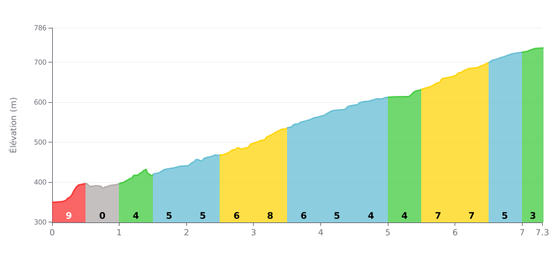
Analysis of the difficulty: This Category 1 climb is moderately hard over its total distance (7.3 km at 6%), but the profile is very uneven. The challenge lies in the constant changes of rhythm: a steep start at 9%, a flat section at 0% between KM 0.5 and 1.0 that breaks your cadence, and a tougher central section between KM 3.0 and 4.0 (gradients of 8% and 6%). The finish is fairly consistent, with gradients around 5-7% over the last two kilometres.
Tips for managing your effort:
1. Handle the start: Resist the temptation to go hard at the bottom. The 9% gradient over the first 500 metres is a trap. Ride within yourself from the get-go so you don't blow your cardiovascular system before the first kilometre is done.
2. Plan for the changes: The flat section (0%) after 500m is a chance to recover actively. Use it to shift into an easier gear, ease the pressure on your legs and find a steady breathing rhythm before the climb ramps up again.
3. Save something for the middle: The steepest part (8%) comes after 3 km. Ride the first half of the climb economically so you have the power you need for this key section without having to empty the tank.
7.3 km • 427 m D+
VAM: average climbing speed, based on elevation gain


Join thousands of cycling fans! Plan your rides, record your performance, track your progress and discover the finest climbs.
Live climb profile to pace your effort all the way to the top.

