
Tong La is a climb of 14.7 kilometers (category 1). Tong La tops out at 5,121 m above sea level. It is located in Shigatsé, 西藏自治区 བོད་རང་སྐྱོང་ལྗོངས།, 中国. The average gradient is 4.4% with a maximum of 9%. The climb has 638 meters of elevation gain.
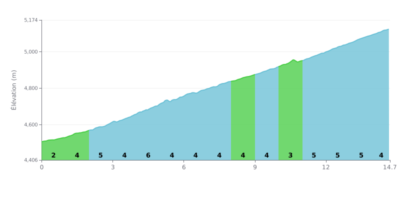
Difficulty breakdown: At 14.7 km, with 638 m of elevation gain and an average gradient of 4.4%, the Tong La is a demanding first category climb, with no truly extreme sections. The first kilometre, at 2%, serves as a warm-up, then the road ramps up between km 2.0 and 5.0, with a peak of 6% between km 4.0 and 5.0. After that, the effort stays steady around 4% up to km 10.0, before a harder final section at 5% from km 11.0 to 14.0 that will make the difference near the top.
Tips for pacing the climb:
1. Save something in the tank. Don't go off too hard on the 2% section from km 0.0 to 1.0, and keep some legs for what comes next.
2. Handle the 6% ramp. Between km 4.0 and 5.0, shift into an easier gear and keep a steady cadence rather than mashing the pedals.
3. Hold it together over the final stretch. From km 11.0 to 14.0, at 5%, stay seated, keep your cadence smooth and dig into your reserves to finish strong.
14.7 km • 638 m D+
VAM: average climbing speed, based on elevation gain


Join thousands of cycling fans! Plan your rides, record your performance, track your progress and discover the finest climbs.
Live climb profile to pace your effort all the way to the top.

