
Tong La is a climb of 98.8 kilometers (hors catégorie). Tong La tops out at 5,121 m above sea level. It is located in n/a, 西藏自治区 བོད་རང་སྐྱོང་ལྗོངས།, 中国. The average gradient is 13.0% with a maximum of 23.6%. The climb has 12883 meters of elevation gain.
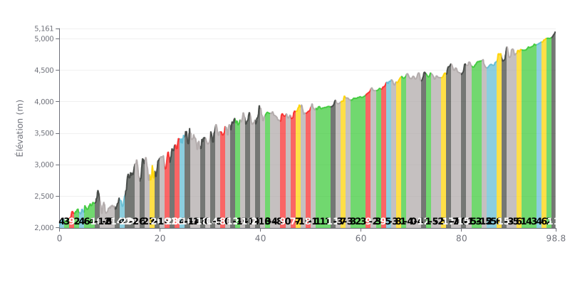
Difficulty analysis: This climb is extremely demanding because of its massive total elevation gain (12,883 m) over a very long distance (98.8 km). The average gradient of 13% is already steep, but the profile is especially hard, with many sections above 20%, and even 30% at KM 16, broken up by technical descents. These sudden changes of gradient put a heavy strain on the heart and the legs.
Pacing advice:
1. Pacing: Settle into a steady rhythm and keep your effort at or just below your aerobic threshold. Resist the urge to go over the top in the steep ramps (e.g. KM 13-14, 16, 22), or you'll blow up early.
2. Use the descents: Use the downhill sections (e.g. KM 8-11, 15, 20) to recover actively by spinning lightly, rather than riding the brakes the whole way, so your legs stay fresh.
3. Fueling strategy: The length of this climb demands a disciplined approach to hydration and nutrition. Plan regular feed stops from the very start to keep your energy stores topped up.
98.8 km • 12883 m D+
VAM: average climbing speed, based on elevation gain


Join thousands of cycling fans! Plan your rides, record your performance, track your progress and discover the finest climbs.
Live climb profile to pace your effort all the way to the top.

