
Quetzaltenango is a climb of 41.3 kilometers (hors catégorie). Quetzaltenango tops out at 2,458 m above sea level. It is located in Santa Cruz Muluá, Retalhuleu, Guatemala. The average gradient is 5.5% with a maximum of 20.2%. The climb has 2279 meters of elevation gain.
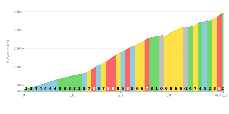
Difficulty breakdown: At 41.3 km averaging 5.5%, this HC climb is a test of endurance. The difficulty lies in its length and its uneven profile: a relatively gentle opening (first 12 km at around 3%), followed by a very demanding central section (km 13 to 26, with frequent gradients of 7-9%), then a deceptive respite (km 26 to 29) before a tough finale (final km at 8-9%).
Pacing advice:
1. Pace yourself: Resist the urge to push hard in the first 12 km, which are relatively flat. Save your legs for the steeper central section.
2. Plan your recovery: Km 26 to 29 (gradient 0-1%) are a crucial chance to recover and refuel before the last difficult part.
3. Save something for the finish: The last 3 km (excluding the flat final stretch) have gradients of 8-9%. Keep some power in reserve so you don't blow up on that final wall.
41.3 km • 2279 m D+
VAM: average climbing speed, based on elevation gain


Join thousands of cycling fans! Plan your rides, record your performance, track your progress and discover the finest climbs.
Live climb profile to pace your effort all the way to the top.

