
Volcán Siete Orejas is a climb of 41.7 kilometers (hors catégorie). Volcán Siete Orejas tops out at 2,629 m above sea level. It is located in Coatepeque, Quetzaltenango, Guatemala. The average gradient is 5.8% with a maximum of 21.2%. The climb has 2425 meters of elevation gain.
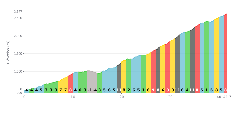
Difficulty breakdown: With 2425m of climbing over 41.7km, this HC climb is a real test of endurance. The 6% average gradient hides an uneven profile: a gentle start (KM 0-10: 3-8%) followed by brutal sections, notably between KM 19-21 (11%, 8%), KM 27 (13%), KM 31 (11%) and KM 34 (11%). The descent at KM 14-15 (-5%) gives you a brief breather, but the steep finish (KM 39-41.7: 8-9%) requires you to have something left in the tank.
Pacing tips:
1. Settle in early: The first 10 km (around 5% average) are forgiving. Use them to find a steady rhythm without redlining, and save your legs for the sections above 10%.
2. Anticipate the spikes: Know where the steep kilometres are (e.g. KM 19, 27, 31, 34). Ease off the pace slightly before these sections so you hit the high gradients without blowing up.
3. Use the recovery stretches: The flatter parts (KM 11-12: 0%, KM 24: 1%) and the descent (KM 14-15) are your chance to recover by spinning easy without pushing.
For cyclists looking for adventure, the climb up Volcán Siete Orejas is a tough but deeply rewarding ride. Riders' accounts agree on a serious difficulty, rated around 7/10, with mostly steep grades and some technical sections where loose sand makes it hard to keep momentum. It's a proper physical challenge that demands commitment, but the payoff is worth the effort.
What makes this climb stand out is its wild character and its incredible views. Riders describe "amazing" vistas over much of the route, with a natural viewpoint looking out over neighboring volcanoes such as Zunil, Atitlán, Santa María and Santiaguito. The volcano itself, with its seven distinct peaks forming a horseshoe-shaped caldera, is a truly grand landscape.
The atmosphere is that of a little-visited place, far from the hustle. The road, accessible by 4x4, is shared with motorbikes and the occasional truck, as one rider who passed one can attest. The track has several different lines, so you need to keep your bearings, ideally riding with someone who knows the way. Accounts also mention that the summit isn't always clear, but the adventure lies in the whole route.
Beyond the effort, the experience is rounded out by discovering the Kum kum wutz Park, a preserved forest zone of over 1,150 hectares. For cyclists, it's a chance to test themselves on authentic terrain and enjoy an intense riding adventure, summed up by this phrase: "asta que no termine la ruta no se vuelve a casa".
41.7 km • 2425 m D+
VAM: average climbing speed, based on elevation gain


Join thousands of cycling fans! Plan your rides, record your performance, track your progress and discover the finest climbs.
Live climb profile to pace your effort all the way to the top.

