
Kis-Kőhát-nyerge is a climb of 10.1 kilometers (category 1). The climb finishes at 835 m above sea level. It is located in Répáshuta, Alföld és Észak, Magyarország. The average gradient is 3.5% with a maximum of 9.8%. The climb has 356 meters of elevation gain.
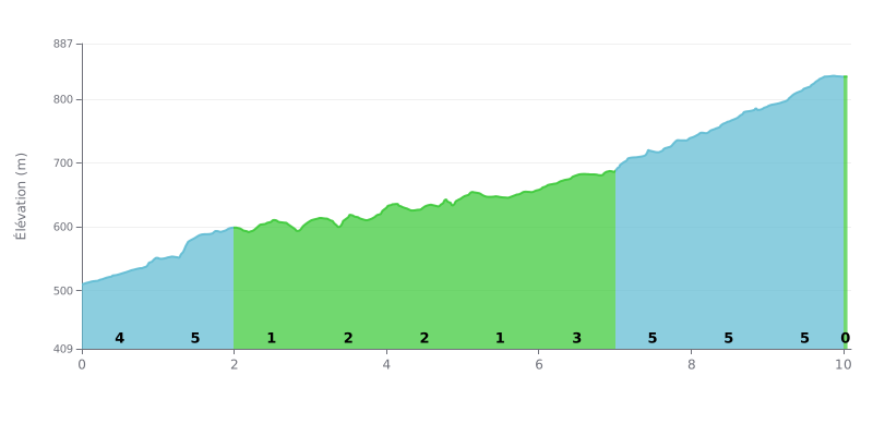
Difficulty analysis: This 10.1 km climb with 356 m of elevation gain averages 3.5%, which may look easy on paper, but the profile is uneven. The start is tough, with 4% over km 0.0-1.0, then 5% over km 1.0-2.0, before a very rolling stretch at 1% over km 2.0-3.0 and km 5.0-6.0. The real difficulty comes in the final third, with a steady 5% over km 7.0-8.0, 8.0-9.0 and 9.0-10.0, where the legs really start to burn.
Pacing tips:
1. Save something for later Don't go out too hard on the 4% section over km 0.0-1.0. You'll need energy for the 5% ramps that follow.
2. Use the flat sections to recover On the 1% stretches over km 2.0-3.0 and 5.0-6.0, soft-pedal, settle back into a steady rhythm, and drink and eat something.
3. Manage your effort for the finish Over km 7.0-8.0, 8.0-9.0 and 9.0-10.0 at 5%, hold a steady gear and cadence, with no surges, so you reach the top with something left in the tank.
A cyclist who did Kis-kőhát from Miskolc talks about a 75 km round trip via Jávorkút and Nagymező. For him, it was a great day on the bike and a good training ride. Along the route, he took plenty of photos in the Bükk.
From Nagymező or from the Bánya-hegy car park, you first follow the paved road. A sign shows where to leave the tarmac: a bulldozed track heads into the forest. It is also an interpretive trail (Kis-kőhát-Nagymező), and green triangle waymarks lead toward Három-kő. A few stones are placed on the boards of the sign. It's about 1 km on this track to reach a junction. Take the left, climb another 400 to 500 m, and you'll reach the Kis-kőhát transmission tower, roughly in the middle of the plateau.
At the top there's a radio tower, which helps with orientation, a house next to it, and a bit further on the summit sign. One cyclist advises paying close attention to the three-stones sign. Another didn't find any marked trail to the summit. You get there through a clearing in the forest.
The weak point comes up again and again in the accounts: there's no view. One cyclist describes the summit as a house and nothing else, and sees no panorama in any direction. The summit offers no panorama, which is the clearest takeaway from these reports.
10.1 km • 356 m D+
VAM: average climbing speed, based on elevation gain


Join thousands of cycling fans! Plan your rides, record your performance, track your progress and discover the finest climbs.
Live climb profile to pace your effort all the way to the top.


Other climbs to Kis-Kőhát-nyerge