
Kis-Kőhát-nyerge is a climb of 13.6 kilometers (category 1). The climb finishes at 836 m above sea level. It is located in Felsőtárkány, Alföld és Észak, Magyarország. The average gradient is 3.4% with a maximum of 9.5%. The climb has 462 meters of elevation gain.
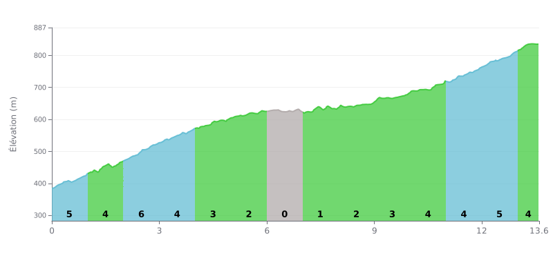
Difficulty analysis: At 13.6 km for 462 m of elevation gain and an average gradient of 3.4%, this Category 1 climb is demanding but within reach of a well-trained cyclist. Most of the effort is concentrated in the first half, with gradients of 4% to 6% between km 0.0 and 4.0, the steepest section being km 2.0 to 3.0 at 6%. Between km 6.0 and 9.0, the road becomes almost rolling (0% to 2%), giving you a real breather. The final stretch, between km 11.0 and 13.0, reminds you that the pass isn't in the bag yet, with gradients of 5% then 4%.
Tips for managing your effort:
1. Pace yourself from the bottom: the first kilometres sit between 4% and 6%, so don't go out too hard before tackling the steepest section, km 2.0 to 3.0.
2. Make the most of the false flat between km 6.0 and 9.0: this is the ideal time to drink, eat and find a steady rhythm before the last part.
3. Save something for the finish: km 11.0 to 13.0, at 5% then 4%, demand a sustained effort, so hold a steady cadence and only go for the final sprint as you approach the summit.
A cyclist who did Kis-kőhát from Miskolc talks about a 75 km round trip via Jávorkút and Nagymező. For him, it was a great day on the bike and a good training ride. Along the route, he took plenty of photos in the Bükk.
From Nagymező or from the Bánya-hegy car park, you first follow the paved road. A sign shows where to leave the tarmac: a bulldozed track heads into the forest. It is also an interpretive trail (Kis-kőhát-Nagymező), and green triangle waymarks lead toward Három-kő. A few stones are placed on the boards of the sign. It's about 1 km on this track to reach a junction. Take the left, climb another 400 to 500 m, and you'll reach the Kis-kőhát transmission tower, roughly in the middle of the plateau.
At the top there's a radio tower, which helps with orientation, a house next to it, and a bit further on the summit sign. One cyclist advises paying close attention to the three-stones sign. Another didn't find any marked trail to the summit. You get there through a clearing in the forest.
The weak point comes up again and again in the accounts: there's no view. One cyclist describes the summit as a house and nothing else, and sees no panorama in any direction. The summit offers no panorama, which is the clearest takeaway from these reports.
13.6 km • 462 m D+
VAM: average climbing speed, based on elevation gain


Join thousands of cycling fans! Plan your rides, record your performance, track your progress and discover the finest climbs.
Live climb profile to pace your effort all the way to the top.


Other climbs to Kis-Kőhát-nyerge