
Temisas is a climb of 11.3 kilometers (category 1). Temisas tops out at 822 m above sea level. It is located in n/a, n/a, España. The average gradient is 5.2% with a maximum of 8.9%. The climb has 591 meters of elevation gain.
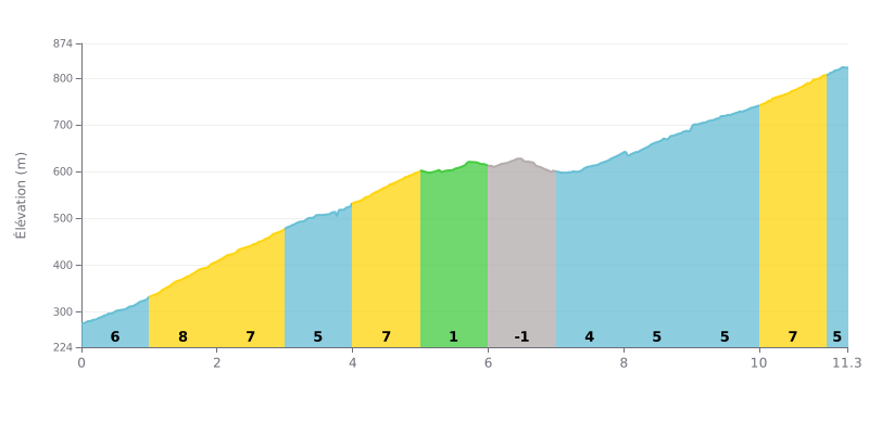
Climb difficulty analysis: This 1st category climb is genuinely hard because of its uneven profile. The first half is demanding, with gradients of 6% to 8% over the first 5 kilometers, followed by a clear respite between kilometers 5 and 7 (1% and -1%). The final push is sustained by a 7% gradient over the last kilometer. The difficulty lies in the alternation between tough sections and short recovery spells.
Pacing advice:
1. Start controlled: Resist the temptation to go out too hard over the first 3 kilometers, the steepest ones (6%-8%). Save some matches for the end.
2. Make the most of the flat: Use the almost flat section (KM 5.0-7.0) to recover actively, keeping a steady rhythm without digging in, but not to attack.
3. Prepare for the finish: Get back into a strong rhythm from KM 8.0 (5% gradient) and get ready for a final all-out effort between KM 10.0 and 11.0 (7%).
11.3 km • 591 m D+
VAM: average climbing speed, based on elevation gain


Join thousands of cycling fans! Plan your rides, record your performance, track your progress and discover the finest climbs.
Live climb profile to pace your effort all the way to the top.


Within 20 km