
Ayagaures is a climb of 7.6 kilometers (category 1). Ayagaures tops out at 486 m above sea level. It is located in n/a, n/a, España. The average gradient is 5.5% with a maximum of 11.9%. The climb has 422 meters of elevation gain.
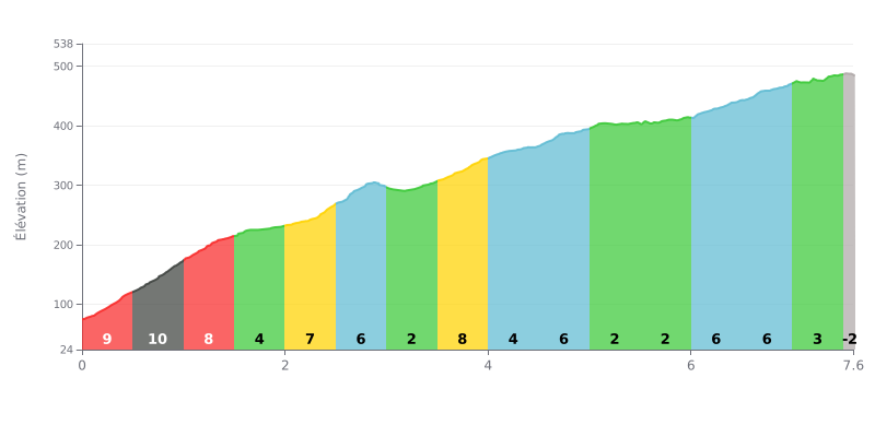
Difficulty breakdown: This Category 1 climb is genuinely hard in its first third, with brutal gradients (9%, 11%, 8%) over the first 2 km. The middle section is more uneven, alternating between moderate stretches (4-8%) and easy-ish sections (2-3%). The difficulty ramps up a bit again towards the end, with two km at 6% before a flat finish.
Pacing advice:
1. Start easy: Don't go out too hard. Don't blow up in the first 2 km. They're the steepest, so save some matches.
2. Active recovery: Use the 5.0 to 6.0 km stretch (2% gradient) to recover by keeping a steady cadence without digging too deep, ahead of the last two kickers.
3. Keep the rhythm even: Adjust your effort to the changes in gradient. Avoid surging on the easier sections so you hit the 6-8% stretches with a steady, controlled effort.
7.6 km • 422 m D+
VAM: average climbing speed, based on elevation gain


Join thousands of cycling fans! Plan your rides, record your performance, track your progress and discover the finest climbs.
Live climb profile to pace your effort all the way to the top.


Within 20 km