
Rila Lakes is a climb of 11.3 kilometers (hors catégorie). Rila Lakes tops out at 1,553 m above sea level. It is located in n/a, Кюстендил, България. The average gradient is 7.2% with a maximum of 12.8%. The climb has 813 meters of elevation gain.
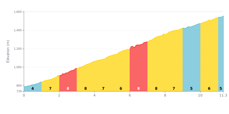
Difficulty breakdown: This HC climb is a sustained effort, owing to its length (11.3 km) and high average gradient (7.2%). The difficulty is compounded by a series of 8% sections (km 2-4 and 6-8) that demand a constant effort. With no real respite, only two short stretches at 5%, it's a demanding one.
How to manage the effort:
1. Pace yourself from the bottom: Resist the temptation to go out too hard despite the "easy" gradient of the first 1000m (5%). Use this section to find your rhythm.
2. Prepare for the hard sections: The 8% stretches (km 2-4 and 6-8) are crucial. Ease off your pace slightly as you approach them so you don't arrive already over the limit.
3. Make the most of km 5 and 9-10: The 6% and 5% sections are your only chances for active recovery. Ease the pressure on the pedals a little to save energy without losing too much speed.
According to riders who have climbed the Seven Rila Lakes, the ascent delivers breathtaking scenery. Each lake, named after its shape (the Kidney, the Eye, the Tear...), has its own beauty, with crystal-clear water reflecting the majestic mountains. The panoramic view from the highest point, where several lakes can be seen at a single glance, is consistently described as unforgettable and spectacular.
Access is made much easier by a chairlift that spares you a very steep initial climb. This makes the approach more accessible, even though the elevation gain remains considerable once you start the hiking trail from the upper station. Riders point out that the main trail is well marked and maintained, but that it can be rocky and slippery in places, requiring constant attention.
The experience can be spoiled by very heavy crowds, especially on weekends and in summer. Long waits for the chairlift and the crowds on the most popular trails are frequently mentioned as a downside, which can take away from the feeling of being at one with nature. It is therefore advisable to favor weekdays for a more peaceful experience.
To fully enjoy the ride, good preparation is essential. Riders recommend sturdy hiking shoes, warm and windproof clothing (the weather changes fast in the mountains), plenty of water and sunscreen. Despite the effort, everyone agrees that the beauty of the place more than rewards every bit of effort.
11.3 km • 813 m D+
VAM: average climbing speed, based on elevation gain


Join thousands of cycling fans! Plan your rides, record your performance, track your progress and discover the finest climbs.
Live climb profile to pace your effort all the way to the top.

