
Ou Kaapse Weg is a climb of 6.6 kilometers (category 2). Ou Kaapse Weg tops out at 307 m above sea level. It is located in n/a, Western Cape, South Africa. The average gradient is 4.7% with a maximum of 10.3%. The climb has 311 meters of elevation gain.
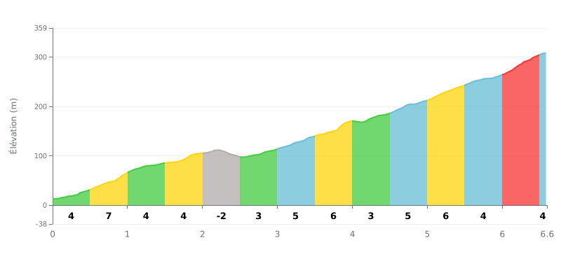
Climb difficulty analysis: This 2nd category climb has an uneven profile. The difficulty lies in the succession of steep sections (7% at km 0.5-1.0 and 8% at km 6.0-6.5) with a short descent at km 2.0-2.5 that breaks the rhythm. The average gradient of 4.7% over 6.6 km is moderate, but the final 500 metres at 8% make for a significant closing challenge.
Pacing advice:
1. Start easy: Resist the urge to chase wheels over the first kilometre at 7%. Save some matches for the finale.
2. Active recovery: Make the most of the slight descent around 2.5 km to ease off a bit without losing all your momentum.
3. Managing the finish: Plan ahead for the last stretch at 8%. Tackle it in a suitable gear with a steady cadence to avoid blowing up.
For cyclists who have climbed it, the ascent of Ou Kaapse Weg is first and foremost a immersive experience through breathtaking scenery. Riders' accounts describe a magnificent road winding through the mountains, offering spectacular views over the valleys below, the ocean in the distance and the lights of Cape Town at night. At certain times of the year, the climb is brightened by the flowering of the fynbos and proteas, creating a truly unique setting.
The climbing experience is often described as a way to escape the heavy traffic along the seafront. However, riders also report that this well-maintained provincial road can become very busy, as it is one of the two main arteries giving access to the Fish Hoek area. This traffic, combined with a dangerous hairpin bend mentioned in riders' accounts, calls for constant vigilance.
The road is about more than just the effort; it is presented as a gateway to other adventures. Riders mention the hiking trails, the Silvermine Nature Reserve and the chance to go for a swim in the dam, making the climb the start of a full day out in nature.
The advice that keeps coming up is to take your time. Whether you stop to capture the view or ride carefully, especially in mist or at dusk, the ride is better enjoyed without rushing. The point is to fully savour the beauty of the place, despite the hazards of traffic.
6.6 km • 311 m D+
VAM: average climbing speed, based on elevation gain


Join thousands of cycling fans! Plan your rides, record your performance, track your progress and discover the finest climbs.
Live climb profile to pace your effort all the way to the top.

