
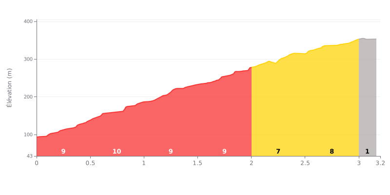
Tafelberg Road is a climb of 3.2 kilometers (category 1). Tafelberg Road tops out at 353 m above sea level. It is located in Cape Town, Western Cape, South Africa. The average gradient is 8.3% with a maximum of 14.7%. The climb has 263 meters of elevation gain.
Analysis of the difficulty:
This Category 1 climb is sustained throughout. The first four half-kilometres (0-2 km) are the toughest, with constant gradients of 9 to 10%. The middle kilometre (2.0-2.5 km) gives you a bit of a breather at 7% before the final section (2.5-3.0 km) ramps back up to 8%. The last 200 metres are flat, giving you a chance to recover at the top.
Tips for managing your effort:
1. Start controlled: Resist the urge to go too hard in the first 2 km, which are very steep. Settle into a steady rhythm to save your legs.
2. Make the most of the breather: Use the 7% section (around 2.0-2.5 km) to ease off a little, shift into an easier gear and recover before the final push.
3. Build back up gradually: Anticipate the end of the climb at 3.0 km and gradually pick up the pace on the flat to finish strong.
For the cyclists who have climbed it, Tafelberg Rd is first and foremost a fully immersive experience in breathtaking scenery. Riders' accounts describe unobstructed, close-up views of Table Mountain, Cape Town, Lion's Head and Signal Hill, and even, on clear days, stunning views out over the ocean.
The ride is defined by the peace and security you feel once you've made it past the gate, since the road is closed to motor traffic. Riders describe an atmosphere that is both lively and calming, with other athletes (runners, hikers) out during the busy hours, which adds to a sense of safety, especially for women. That said, several riders warn against going up alone after dark.
The road itself offers a unique setting that changes with the seasons. In winter or after rain, the climb becomes spectacular, with numerous waterfalls tumbling down the mountain and sometimes crossing the road. The local wildlife, such as mongooses, can also surprise climbers. But the experience stays realistic: some riders report rockfalls on the road, so keep your wits about you.
Beyond the effort, riders who share their experiences stress that this climb is a must-do, a world-famous ascent that leaves a lasting memory, whether at sunrise, at sunset, or simply for the raw beauty of the mountain landscape.
3.2 km • 263 m D+
VAM: average climbing speed, based on elevation gain


Join thousands of cycling fans! Plan your rides, record your performance, track your progress and discover the finest climbs.
Live climb profile to pace your effort all the way to the top.


Within 20 km