
Mount Tabac Viewpoint is a climb of 4.8 kilometers (hors catégorie). Mount Tabac Viewpoint tops out at 478 m above sea level. It is located in n/a, Soufrière, Saint Lucia. The average gradient is 11.3% with a maximum of 18.9%. The climb has 537 meters of elevation gain.
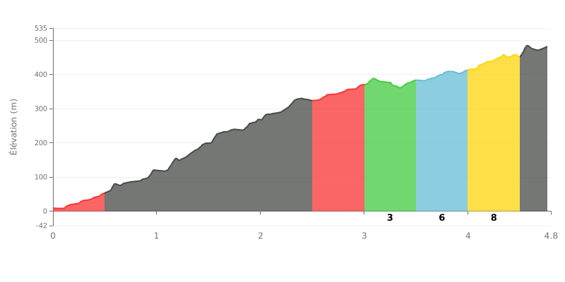
Difficulty breakdown: This climb is extremely hard because of its very high average gradient (11.3%) over a substantial distance. The difficulty is concentrated in the first half, with maximum gradients of 16% between km 1.0 and 1.5, making it the key section. There's a relative respite between 3.0 and 3.5 km (3%), before the gradient gradually ramps back up to the finish.
How to manage the effort:
1. Measured start: Resist the urge to go out too hard. Pace yourself on the first 9-13% so you hit the 16% wall with something left in the tank.
2. Focus on the 1.0-2.0 km stretch: This is the heart of the climb. Stay in a very easy gear and keep a steady cadence to get through this decisive section.
3. Make the most of the KM 3 recovery: The 3% section is a crucial chance to recover and take on fuel before the final gradual drag to the finish.
4.8 km • 537 m D+
VAM: average climbing speed, based on elevation gain


Join thousands of cycling fans! Plan your rides, record your performance, track your progress and discover the finest climbs.
Live climb profile to pace your effort all the way to the top.


Other climbs to Mount Tabac Viewpoint