
Mount Tabac Viewpoint is a climb of 6.0 kilometers (hors catégorie). Mount Tabac Viewpoint tops out at 478 m above sea level. It is located in Canaries, Canaries, Saint Lucia. The average gradient is 8.8% with a maximum of 15.8%. The climb has 530 meters of elevation gain.
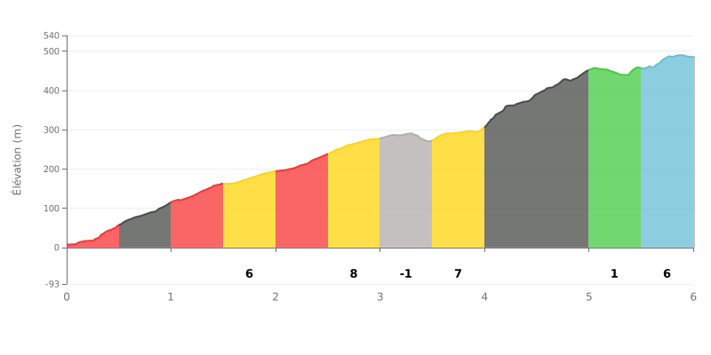
Difficulty breakdown: This 6 km climb averages 8.8% over 530 m of elevation gain. It's rated HC and demands a sustained effort from bottom to top. The first two km, at 10% to 12%, set a demanding pace right from the gun. The crux comes between km 4.0 and 4.5 at 17%, followed by 12% from km 4.5 to 5.0. The section from km 5.0 to 5.5, at 1%, gives you a short recovery before the final 6% km.
Pacing tips:
1. Control the start: Don't go too hard through the opening 10% and 12% km, and settle into a steady cadence from the get-go.
2. Prepare for the 17% ramp: Shift to an easier gear before km 4.0, then stay seated to keep your cadence steady through the steepest part.
3. Use the flat: Make the most of the 1% section from km 5.0 to 5.5 to recover, fuel up and get your position back before the final 6%.
6.0 km • 530 m D+
VAM: average climbing speed, based on elevation gain


Join thousands of cycling fans! Plan your rides, record your performance, track your progress and discover the finest climbs.
Live climb profile to pace your effort all the way to the top.

