
Mont chelia is a climb of 16.8 kilometers (hors catégorie). Mont chelia tops out at 2,286 m above sea level. It is located in n/a, Batna, Algérie ⵍⵣⵣⴰⵢⴻⵔ الجزائر. The average gradient is 5.6% with a maximum of 15.6%. The climb has 936 meters of elevation gain.
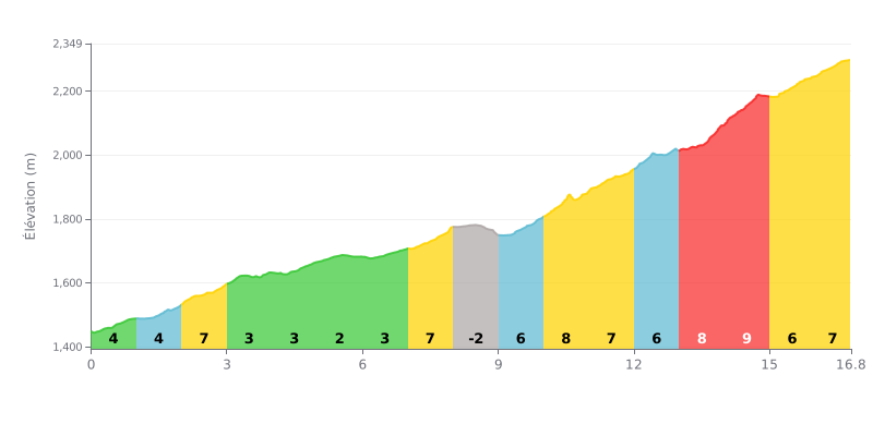
Difficulty analysis: This 16.8 km beyond category climb has real difficulty in the final section. The first half is fairly moderate (gradients often between 2% and 5%), but the second half, especially between km 10 and 15, is demanding with sustained gradients of 7% to 9%.
Pacing advice:
1. Managing your pace: Make the most of the early kilometres and the descent at km 8-9 to recover. Don't go out too hard, so you save something for the brutal gradients at the end.
2. Preparing for the key sections: The four consecutive kilometres between 10 and 14 (8%, 7%, 6%, 8%) and the km 14-15 stretch at 9% are the hardest. Tackle them with an appropriate gear and a steady rhythm.
Riders who have climbed Djebel Chélia describe an epic climb in the heart of the Aurès, topping out at 2328 meters. For many, reaching the summit, known as Pic Keltoum, brings an intense sense of accomplishment, often compared to acing an exam. It is the second-highest peak in Algeria and the highest in the north of the country, a goal that really drives climbers.
The ride is marked by stunning, varied scenery. Riders talk about wild nature, with centuries-old cedar forests, clean mountain air and jaw-dropping views that open up all the way up. In winter the show is different but just as striking, with a summit that is often snow-covered and offers a contrasting panorama. However, some riders point to a lack of signage on the tracks, advising you to do your homework beforehand.
While the road is generally described as safe and the difficulty is rated as moderate, the climb takes serious effort. Riders warn about the letdown on the descent, which can feel endless. A recurring complaint in shared reports is litter in the more accessible areas, which clashes with the natural beauty of the place, and visitors are calling for better preservation.
Still, the atmosphere at the top is described as calm and soothing, a real haven of peace. Riders highlight the unique feeling of breathing clean air and enjoying an almost spiritual silence, although some note the isolation of the site and the lack of phone signal. According to riders, it's an experience that stays with you and is worth doing at least once in your life.
16.8 km • 936 m D+
VAM: average climbing speed, based on elevation gain


Join thousands of cycling fans! Plan your rides, record your performance, track your progress and discover the finest climbs.
Live climb profile to pace your effort all the way to the top.

