
Mont Aconcagua is a climb of 91.7 kilometers (hors catégorie). Mont Aconcagua tops out at 3,831 m above sea level. It is located in n/a, Mendoza, Argentina. The average gradient is 3.0% with a maximum of 16.1%. The climb has 2790 meters of elevation gain.
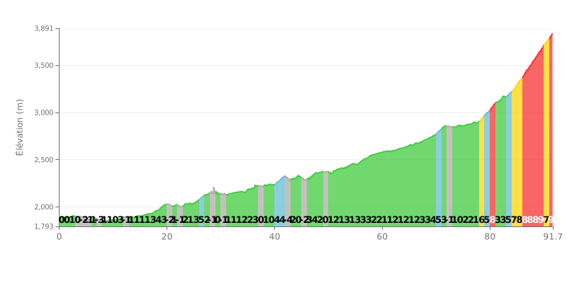
Difficulty analysis: At 91.7 km and 2790m of climbing, this HC ascent is an extreme endurance test. The 3% average gradient is misleading: the first third is very flat (most of it at 0-1%), the second third has moderate gradients (2-4%), and the last 20 km are brutal, with sustained gradients of 7% to 9%.
Tips for the effort:
1. Pacing: Resist the urge to go hard in the first 70 km, which are relatively easy. The climb really starts after km 78. Save your legs for the steep final section.
2. Fueling and hydration: The expected duration of the effort (over 3 hours for a trained cyclist) demands a rigorous nutrition strategy. Fuel regularly from the very start.
3. Final push: The last 14 km (km 78 to 91.7) concentrate the climbing into steep gradients. Prepare mentally and physically for this decisive section.
Cyclists who have climbed Aconcagua describe an experience that goes far beyond a simple summit push. For many, it's a dream come true, a one-of-a-kind adventure at the foot of the highest mountain in the Americas. The scenery is unanimously praised as breathtaking, whether from the approach road, with jaw-dropping views over the Andes Cordillera, or from the trails in the provincial park.
The experience varies a lot depending on your goal. Riders report easy treks of one to two hours from the park entrance, perfect for a family outing, all the way up to the demanding expedition to the summit at nearly 7,000 meters, which calls for serious physical and logistical prep. Cyclists stress the importance of altitude acclimatization and the need to plan several days, or even weeks, for a serious summit attempt, where the lack of oxygen becomes the main challenge.
Several practical points come up again and again. Buying your entry permit online in advance is strongly recommended, since internet access on site is often patchy or nonexistent. It's also key to bring proper layers for changing conditions: a hot sun can quickly give way to a freezing wind, even in summer. Finally, if you're aiming for the top, booking with experienced outfitters or guides is often described as a real asset for logistics and safety.
Despite the beauty of the place, some riders point to limited tourist facilities at the park entrance (basic toilets, for example) and difficulties for foreigners with the online permit payment process. Still, the emotion of facing such vast landscapes and the sense of accomplishment outweigh everything else, making this climb an unforgettable memory for those who've done it.
91.7 km • 2790 m D+
VAM: average climbing speed, based on elevation gain


Join thousands of cycling fans! Plan your rides, record your performance, track your progress and discover the finest climbs.
Live climb profile to pace your effort all the way to the top.

