
Paso de la Cumbre (Tunnel) is a climb of 61.3 kilometers (hors catégorie). Paso de la Cumbre (Tunnel) tops out at 3,179 m above sea level. It is located in Los Andes, Región de Valparaíso, Chile. The average gradient is 4.1% with a maximum of 13%. The climb has 2517 meters of elevation gain.
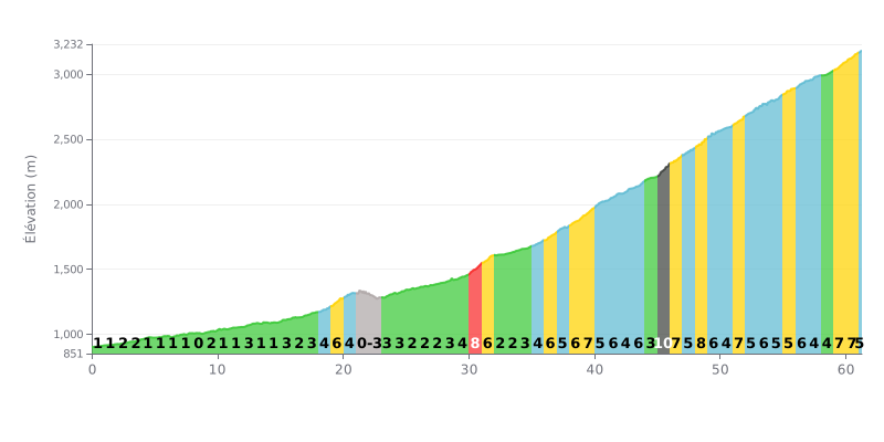
Difficulty breakdown: This hors catégorie climb covers 61.3 km and is a true endurance test. The difficulty lies in its length and its two-part profile: the first 30 km have moderate gradients (1-3%), followed by a much steeper second section (4-10%) from km 30 onward, with brutal stretches like km 45 at 10%.
Pacing advice:
1. Pace management: Ride at an endurance pace (Zone 2) through the first third to save your legs. Build the effort gradually after KM 30 without blowing up.
2. Anticipate the key sections: Note the steepest kilometres (e.g. KM 30, 45, 48, 59) and drop to an easier gear as you approach them to keep a steady cadence.
3. Strategic fueling: The duration demands strict hydration and nutrition. Plan your feed stops before the hard sections (around KM 30 and 45).
61.3 km • 2517 m D+
VAM: average climbing speed, based on elevation gain


Join thousands of cycling fans! Plan your rides, record your performance, track your progress and discover the finest climbs.
Live climb profile to pace your effort all the way to the top.

