
Mohankhal is a climb of 31.0 kilometers (hors catégorie). Mohankhal tops out at 2,182 m above sea level. It is located in n/a, Uttarakhand, India. The average gradient is 10.4% with a maximum of 12.5%. The climb has 3239 meters of elevation gain.
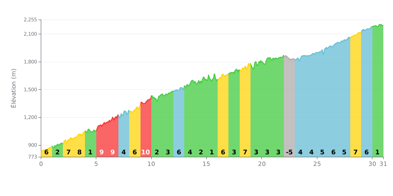
Difficulty breakdown: This 31 km climb averaging 10% is extremely demanding because of its 3239 m of total elevation gain. The real challenge is the uneven profile: many kilometers at 7% to 9% (KM 5-6-7-8-9-16-28) alternate with easier stretches (1-3%) and a short descent at KM 22. That breaks your rhythm and demands disciplined pacing.
Pacing tips:
1. Settle into a steady rhythm by targeting a power or heart rate that suits the 10% average, without overcooking it on the 9% ramps.
2. Make the most of the easier sections (KM 1, 4, 10, 11, 14, 15, 17, 19, 21, 30) to recover actively: keep the legs turning without forcing it.
3. Plan for the descent at KM 22 so you're recovered before the final 8 kilometers, which hold a sustained 5-7% gradient.
31.0 km • 3239 m D+
VAM: average climbing speed, based on elevation gain


Join thousands of cycling fans! Plan your rides, record your performance, track your progress and discover the finest climbs.
Live climb profile to pace your effort all the way to the top.


Other climbs to Mohankhal