
Mohankhal is a climb of 18.6 kilometers (hors catégorie). Mohankhal tops out at 2,182 m above sea level. It is located in Kansill, Uttarakhand, India. The average gradient is 7.2% with a maximum of 17.1%. The climb has 1334 meters of elevation gain.
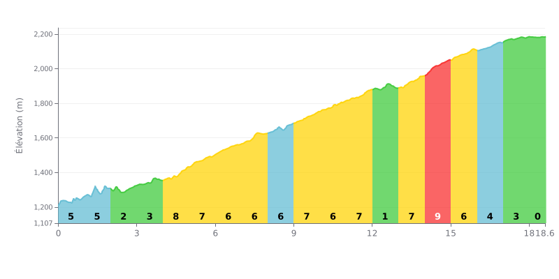
Difficulty breakdown: At 18.6 km, with an average gradient of 7.2% and 1334 m of elevation gain, this HC climb demands sustained effort management. After a gentler start up to km 3.0, the gradient ramps to 8% from km 4.0-5.0, then sits between 6% and 7% until km 12.0, with only a brief respite at 1% from km 12.0-13.0. The steepest section comes at km 14.0-15.0 at 9%, before a more gradual finish up to km 18.0.
Effort tips:
1. Pace your start. From km 0.0-3.0, the moderate gradient tempts you to go too hard, but stay at threshold so you reach the longest part of the climb with fresh legs.
2. Manage the 6-7% section. Through km 4.0-5.0 at 8% and then from km 5.0 to km 12.0, favor a light gear and a steady cadence to save your legs.
3. Use the km 12.0-13.0 respite. At 1%, eat, drink and pick up your cadence again before tackling the 9% section at km 14.0-15.0.
18.6 km • 1334 m D+
VAM: average climbing speed, based on elevation gain


Join thousands of cycling fans! Plan your rides, record your performance, track your progress and discover the finest climbs.
Live climb profile to pace your effort all the way to the top.


Other climbs to Mohankhal