
Alto de Cachinal is a climb of 104.1 kilometers (hors catégorie). Alto de Cachinal tops out at 4,047 m above sea level. It is located in n/a, Salta, Argentina. The average gradient is 2.8% with a maximum of 13.8%. The climb has 2895 meters of elevation gain.
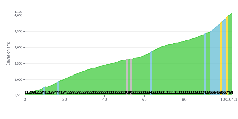
Difficulty breakdown: At 104.1 km and 2895 m of climbing, this HC climb is an extreme endurance test. Its 3% average gradient is deceptive: the first 80 km are mostly 1% to 4%, which demands a steady rhythm. The real difficulty lies in the last 20 km, where the gradient ramps up sharply to 5% to 8%, making for a very demanding finale.
Effort management tips:
1. Pacing: Keep your intensity steady and moderate over the first 80 km (Zone 2) to save your legs. Avoid going over your limit on the false flats at all costs.
2. Plan for the finale: Save some energy and mental reserves for the critical section from KM 93 to KM 101, where the gradient goes above 5% with a peak at 8%.
3. Fueling strategy: Drink and eat regularly from the very start. The length of this climb makes nutrition and hydration just as crucial as managing your effort.
104.1 km • 2895 m D+
VAM: average climbing speed, based on elevation gain


Join thousands of cycling fans! Plan your rides, record your performance, track your progress and discover the finest climbs.
Live climb profile to pace your effort all the way to the top.

