
Abra Blanca is a climb of 105.5 kilometers (hors catégorie). Abra Blanca tops out at 4,090 m above sea level. It is located in n/a, Salta, Argentina. The average gradient is 2.7% with a maximum of 12%. The climb has 2871 meters of elevation gain.
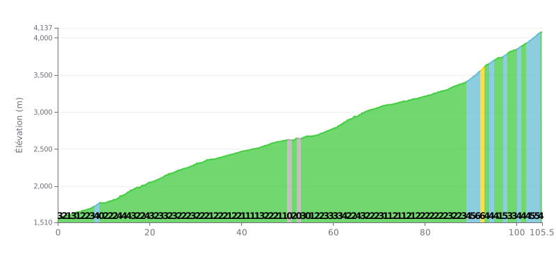
Difficulty breakdown: This 105.5 km climb is a pure endurance test. The 3% average gradient is deceptive: with 2871m of elevation gain over that distance, it's a proper HC-category monster. The difficulty lies in its length and the lack of any real respite, with most of the road sitting between 2% and 4%. The final section (KM 89-105) has the steepest gradients (4% to 6%), which makes the finish particularly brutal.
Pacing and effort management:
1. Pacing: Settle into a steady, controlled tempo from the bottom. Don't go off the front in the first few kilometres. Save your legs for the long haul.
2. Save something for the end: Keep some gas in the tank for the last 15 kilometres, where the gradient regularly goes over 4%. The steepest part is between km 91 and 93 (6%).
3. Fuelling strategy: At this length, you need to be disciplined with both hydration and nutrition. Plan frequent fuel stops to keep your energy topped up throughout the effort.
For those who have climbed it, the ascent of Abra Blanca is first and foremost an altitude experience, with a summit at over 4000 meters. Riders talk about having to manage the "apuna", the altitude sickness, by going "despacio", slowly, once they reach the top.
Despite the difficulty, riders are unanimous about the scenery, describing it as arid but "bellisimos" and "espectacular". The spot is seen as a "lugar mágico", a magical place that pays off the effort with views that are worth every pedal stroke.
The road itself is described as "buen camino", serving as the gateway to San Antonio de los Cobres. For many, reaching this pass is a "milowy", a historic milestone, and a "mundial" experience, unique in the world.
105.5 km • 2871 m D+
VAM: average climbing speed, based on elevation gain


Join thousands of cycling fans! Plan your rides, record your performance, track your progress and discover the finest climbs.
Live climb profile to pace your effort all the way to the top.


Within 20 km