
Ntunga is a climb of 6.6 kilometers (category 3). Ntunga tops out at 1,676 m above sea level. It is located in Mwulire, Eastern Province, Rwanda. The average gradient is 3.5% with a maximum of 10.5%. The climb has 232 meters of elevation gain.
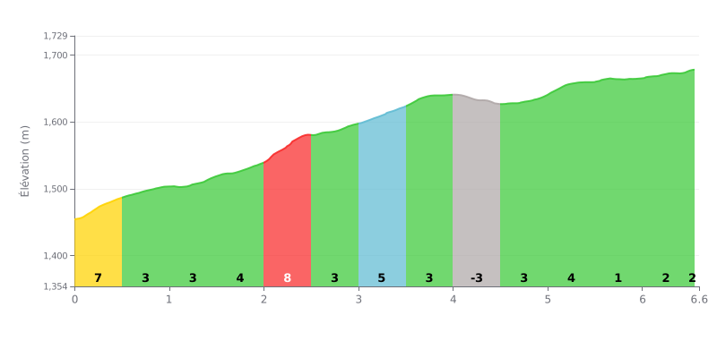
Difficulty analysis: The Col de Ntunga, rated 3rd category, covers 6.6 km of climbing for 232 m of elevation gain, with an average gradient of 3.5%. The start is tough, with 7% over the first 500 metres, and the hardest section comes between 2.0 and 2.5 km, where the gradient reaches 8%. The real challenge is the mix of steep ramps and flatter, rolling stretches, which makes it hard to find a steady rhythm.
Pacing tips:
1. Manage the start. On the first 500 metres at 7%, stay in the saddle and keep a smooth cadence so you don't blow up right from the bottom.
2. Prepare for the 8% section. Between 2.0 and 2.5 km, shift to an easier gear before the steepest pitch and hold a steady cadence.
3. Use the descent to recover. The 4.0 to 4.5 km section, a gentle descent (-3%), gives you time to drink, eat and loosen up your legs before the finish, which is easier between 5.5 and 6.5 km.
6.6 km • 232 m D+
VAM: average climbing speed, based on elevation gain


Join thousands of cycling fans! Plan your rides, record your performance, track your progress and discover the finest climbs.
Live climb profile to pace your effort all the way to the top.


Other climbs to Ntunga