
Gacila Shan is a climb of 15.9 kilometers (category 1). The climb finishes at 4,488 m above sea level. It is located in Markam, 西藏自治区 བོད་རང་སྐྱོང་ལྗོངས།, 中国. The average gradient is 4.5% with a maximum of 12.5%. The climb has 719 meters of elevation gain.
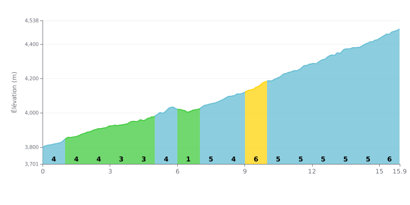
Difficulty breakdown: At 15.9 km, 719 m of elevation gain and an average gradient of 4.5%, the climb of 噶次拉山 from Luonicun is rated Cat 1 and demands a sustained effort over the long haul. The first six kilometres, between 3% and 5%, call for a steady rhythm, before a clear flat section at KM 6.0-7.0 (1%). The second part, from KM 7.0 to KM 15.9, is almost continuous between 5% and 6%, with no real respite, which makes it particularly demanding both physically and mentally.
Tips for managing your effort:
1. Pace yourself from the start On the KM 0.0-1.0 section at 5%, hold a comfortable cadence and gear so you still have legs left for the long stretch from KM 7.0 to KM 15.9.
2. Recover on the flat Use the KM 6.0-7.0 section at 1% to drink, eat and get the legs turning again before the hardest part.
3. Handling the 6% sections On KM 9.0-10.0 and KM 15.0-15.9, stay smooth, move into the saddle if needed, and don't go into the red by starting too hard.
15.9 km • 719 m D+
VAM: average climbing speed, based on elevation gain


Join thousands of cycling fans! Plan your rides, record your performance, track your progress and discover the finest climbs.
Live climb profile to pace your effort all the way to the top.

