
Gacila Shan is a climb of 12.4 kilometers (category 1). The climb finishes at 4,493 m above sea level. It is located in Chamdo, 西藏自治区 བོད་རང་སྐྱོང་ལྗོངས།, 中国. The average gradient is 4.4% with a maximum of 10.4%. The climb has 545 meters of elevation gain.
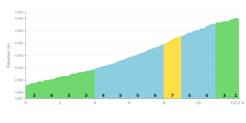
Difficulty analysis: The 噶次拉山 climbs over 12.4 km for 545 m of elevation gain, with an average gradient of 4.4%, which puts it in Category 1. The climb is gradual: the first four kilometres are rolling, between 3 and 4%. The difficulty ramps up between km 5 and km 11, where the gradient hovers between 5 and 6%, with peaks on km 7-8, 8-9 and 10-11. The final section is easier (3% then 1%), offering a welcome break but not making up for the length of the central part.
Tips for managing your effort:
1. Start easy For the first 4 km (3 to 4%), spin at a moderate pace to save some energy for the central section.
2. Manage the km 5 to km 11 section Get into a small gear with a steady cadence so you don't blow up on the 6% stretches.
3. Attack the final section Once past km 11, the gradient drops to 3% then 1%: use that breather to push the pace all the way to the summit.
12.4 km • 545 m D+
VAM: average climbing speed, based on elevation gain


Join thousands of cycling fans! Plan your rides, record your performance, track your progress and discover the finest climbs.
Live climb profile to pace your effort all the way to the top.

