
Runok is a climb of 5.2 kilometers (category 3). The climb finishes at 665 m above sea level. It is located in Liucea, Івано-Франківська область, Україна. The average gradient is 3.6% with a maximum of 9.5%. The climb has 189 meters of elevation gain.
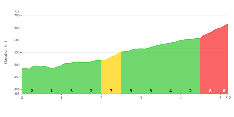
Climb analysis: Runok from Merishor is a Category 3 climb covering 5.2 km with 189 m of elevation gain and a moderate average gradient of 3.6%. The difficulty comes mainly from three steep sections: KM 2.0-2.5 at 7%, KM 4.5-5.0 at 8%, and KM 5.0-5.2 at 9%, the last one being the hardest part of the ascent. Between these sections, KM 0.0-0.5, 0.5-1.0 and 4.0-4.5 have easier gradients (1 to 2%) where you can recover.
Tips for managing your effort:
1. Pace yourself at the start: KM 0.0-0.5 and 0.5-1.0 are almost flat, so use them to find your rhythm without blowing up before the hard parts.
2. Handle the ramp at KM 2.0-2.5: tackle this 7% section in an easy gear with a smooth cadence, and don't mash the pedals.
3. Save your legs for the finish: use the 2% stretch at KM 4.0-4.5 to recover, then keep some energy in the tank for KM 4.5-5.0 at 8% and KM 5.0-5.2 at 9%.
5.2 km • 189 m D+
VAM: average climbing speed, based on elevation gain


Join thousands of cycling fans! Plan your rides, record your performance, track your progress and discover the finest climbs.
Live climb profile to pace your effort all the way to the top.

