
Mtae is a climb of 9.2 kilometers (hors catégorie). Mtae tops out at 1,588 m above sea level. It is located in Langoni, Tanga, Tanzania. The average gradient is 11.6% with a maximum of 19.2%. The climb has 1066 meters of elevation gain.
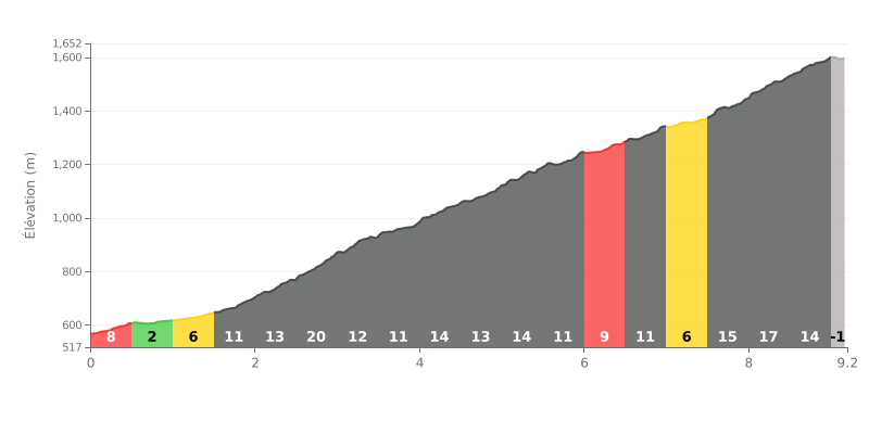
Difficulty breakdown: This HC climb is brutally hard. The average gradient of 12% over 9.2 km is already very steep, but the distribution makes it even harder: more than half of the segments are above 13%, with a vicious 20% ramp between 2.5 and 3.0 km. The finale is especially nasty, with 15% and 17% gradients in the last few kilometres.
Pacing tips:
1. Pace yourself from the start: Resist the urge to go too hard in the first kilometres (8% and 2% sections) so you save your legs for the critical 13-20% stretches.
2. Prepare for the spikes: The 20% kilometre (around 2.5 km) is the hardest. Tackle it with an easy gear and a steady cadence so you don't blow up early.
3. Save something for the end: The last three kilometres (15%, 17%, 13%) are very steep. Manage your effort mid-climb so you still have the legs to reach the summit.
9.2 km • 1066 m D+
VAM: average climbing speed, based on elevation gain


Join thousands of cycling fans! Plan your rides, record your performance, track your progress and discover the finest climbs.
Live climb profile to pace your effort all the way to the top.

