
El Brezal is a climb of 7.8 kilometers (category 3). El Brezal tops out at 535 m above sea level. It is located in La Atalaya, n/a, España. The average gradient is 4.3% with a maximum of 7.7%. The climb has 334 meters of elevation gain.
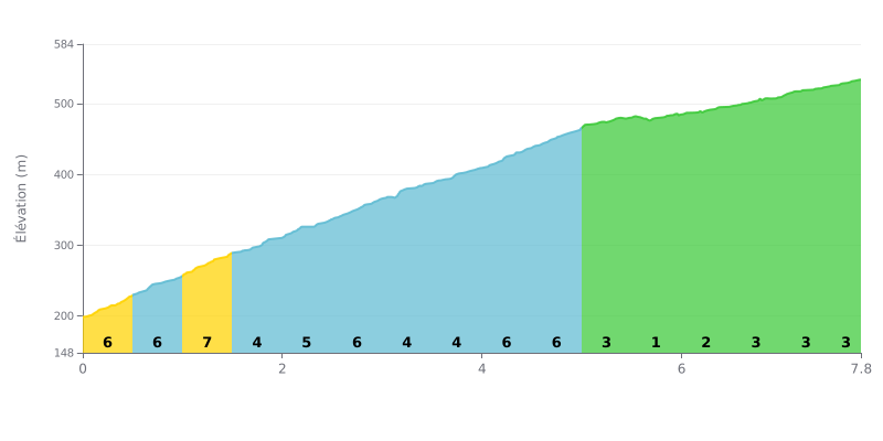
Difficulty analysis: The climb of La Atalaya (7.8 km, 4.3%) is a category 3 climb, steady and consistent. The main challenge is the first half (KM 0.0 to 5.0), with a series of sections at 5-6% that demand a sustained effort. The second part (KM 5.0 to 7.8) is much easier (1-3%), giving you a chance to recover before the finish.
How to manage your effort:
1. Start conservatively: Don't let the early kilometres at 6% fool you into going too hard. Find a steady rhythm you can hold over the first 5 km.
2. Use the second half to recover: From KM 5.0, the gradient eases off considerably (1-3%). This is the time to ease off a little, drink, and get your breath back.
3. Ride a smooth gear: The consistent gradients let you keep a steady cadence. Anticipate the short 6% sections so you don't lose your rhythm.
Cyclists who have climbed El Brezal describe being immersed in a unique natural landscape, a preserved remnant of the island's old forests. They talk about riding up through "el brezal más importante de la isla", a "bosque de brezos espectacular" and "naturaleza en estado puro" that gives a real break from urban life.
The ride is defined by the tranquillity and serenity of the place. Riders stress the quiet, where you hear nothing but "los ruedo solo pájaros y animales", and the feeling of "aire limpio y paz". It's a climb that lets you get "perderse por ahí" and reconnect with well-preserved nature.
The road passes through an area with visitor facilities that riders appreciate, such as the merenderos with barbacoas. However, some cyclists mention that access can be "un poco complicado", something to factor into your planning before heading out.
At the top or in the surrounding area, climbers can enjoy "vistas inmejorables" over the ravines and countryside. The atmosphere is described as family-friendly and relaxed, perfect for a well-earned recovery after the effort, in a setting that makes you feel you're discovering "lo más bonito de Gran Canaria".
7.8 km • 334 m D+
VAM: average climbing speed, based on elevation gain


Join thousands of cycling fans! Plan your rides, record your performance, track your progress and discover the finest climbs.
Live climb profile to pace your effort all the way to the top.


Other climbs to El Brezal
Within 20 km