
Kraljeva stolica is a climb of 6.6 kilometers (category 2). The climb finishes at 498 m above sea level. It is located in Irig, n/a, Србија. The average gradient is 4.2% with a maximum of 11%. The climb has 275 meters of elevation gain.
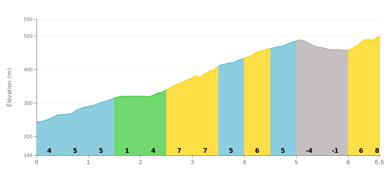
Difficulty analysis: With 6.6 km for 275 m of elevation gain and an average gradient of 4.2%, the Kraljeva stolica climb is rated Category 2 and demands sustained effort, though it's within reach of any regular rider. The real test lies in two 7% sections: from km 2.5 to km 3.5, then from km 6.0 right up to the finish, the final ramp coming straight after a descent that breaks your rhythm. The profile stays uneven, with no long flat-ish stretch to recover on, so pacing is everything.
Pacing tips:
1. Go easy at the start Don't get carried away by the 4 to 5% gradients of the first kilometres (km 0.0 to 1.5). Spin a relaxed cadence so you reach the 7% sections with legs still fresh.
2. Recover between the steep bits Make the most of the 1% stretch from km 1.5 to km 2.0 to shake out your legs and build a bit of momentum before the steeper climb that follows.
3. Plan for the finishing ramps Get into a suitable gear by km 2.5 and keep a steady cadence through the 7% section from km 2.5 to km 3.5, and again through the last part of the km 6.0 stretch to the finish, without surging too early.
Accounts of Kraljeva stolica (the "King's Throne") are almost all about hiking. The pass sits on the ridge line of the Fruška gora, at over 500 m of elevation, west of the Iriški venac. On the Novi Sad side the gradient is steeper than on the south side. From Popovica or Ledinci the climb is short, under an hour according to one hiker, with one slightly tough section. Only one account mentions MTB, and none describes a climb on a road bike in any detail.
What comes up most is the forest. Several people describe a big, dense beech forest, fresh air, quiet, and birdsong. The trails are well marked, there are benches and tables for a break, and the pass is a junction of forest tracks. An 11 km loop links Popovica to the Iriški venac via Kraljeva stolica. Others do an out-and-back to the Zvačan spring. The trail is part of the official Fruška gora route, and the spot serves as a checkpoint for the mountain marathon. At the start of the trail, the Gorski Smešak café is often mentioned.
The downsides come up too. A paved road runs past the pass, and some feel the traffic spoils the place. One witness reports about 250 m of asphalt heading towards Popovica. Others complain about cars driving deep into the forest with barbecues and coolers, signs of tree felling, and litter left behind by some visitors. There's no water to fill bottles, no shop or kiosk on site, and one visitor found the service lacking. One person felt the place isn't well maintained.
For a cyclist, the pass is mostly a rest stop on the mountain roads. The accounts say nothing specific about road surface or gradients on the bike, apart from the shortness of the climb and the stretches of asphalt. Set off knowing you won't find water or food on site.
6.6 km • 275 m D+
VAM: average climbing speed, based on elevation gain


Join thousands of cycling fans! Plan your rides, record your performance, track your progress and discover the finest climbs.
Live climb profile to pace your effort all the way to the top.


Other climbs to Kraljeva stolica
Within 20 km