
Popov cot is a climb of 3.3 kilometers (category 2). The climb finishes at 450 m above sea level. It is located in Grgurevci, n/a, Србија. The average gradient is 7.4% with a maximum of 14.9%. The climb has 243 meters of elevation gain.
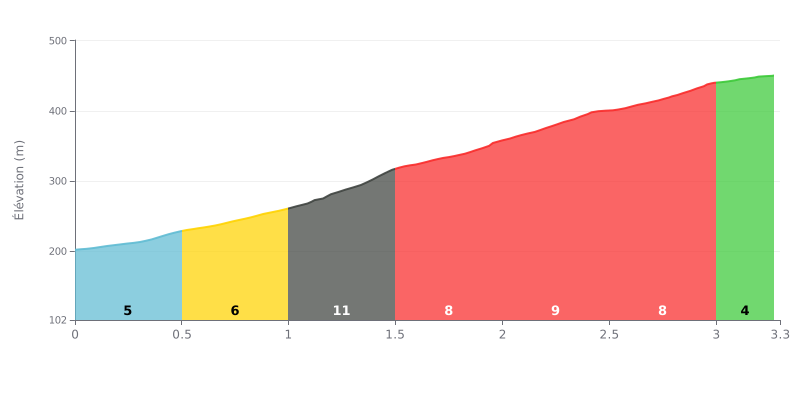
Difficulty breakdown: Popov Cot from Grgurevci is a 3.3 km climb with 243 m of elevation gain, averaging 7.4%, which earns it a Category 2 classification. The km 0.0-0.5 section at 5% is a warm-up, then km 0.5-1.0 (7%) and especially km 1.0-1.5 (11%) really ramp up the climb. Between km 1.5 and 3.0 the gradient stays solid at around 8% with no real respite, before a more manageable final stretch from km 3.0-3.3 at 4%. It's a sustained effort that calls for pacing over the long haul rather than just one explosive burst.
Tips for the effort:
1. Pace your start Don't go out too hard on the km 0.0-0.5 section at 5% so you have something left for the 11% ramp at km 1.0-1.5.
2. Prepare for the hardest part Shift to an easier gear from km 0.5-1.0 so you hit km 1.0-1.5 with a smooth cadence and no jerky pedaling.
3. Don't ease off near the top Hold your effort through km 2.5-3.0 at 8%, then use the km 3.0-3.3 section at 4% to push the pace and finish strong.
Cyclists talking about the Popov čot mostly talk about the rest stop. Several describe a small clearing in the shade of the trees, with wooden tables and benches. One witness finds it perfect for all kinds of outdoor get-togethers, with two tables on a small meadow, and says it's a good spot to go when you want to avoid the crowds at Letenka.
The vibe comes up often. It's quiet and peaceful, and families with young kids appreciate it. Some people come to walk in the forest, others to fire up a barbecue. It's also an important junction for hiking trails.
The downsides get mentioned too. The fountain is often out of order, and one rider isn't sure there's any drinkable water, so it's best to set off with your own supplies. The local hut wasn't open on one visit. The grass isn't always mowed, and the vegetation can block the view in places. The spot is right by the road.
On the road side, one witness says the way up to Grgurevci is paved. Reports say little about the climb itself and mostly describe arriving at the rest stop.
3.3 km • 243 m D+
VAM: average climbing speed, based on elevation gain


Join thousands of cycling fans! Plan your rides, record your performance, track your progress and discover the finest climbs.
Live climb profile to pace your effort all the way to the top.


Within 20 km