
Grajnár is a climb of 5.4 kilometers (category 3). The climb finishes at 1,023 m above sea level. It is located in Hnilčík, Košický kraj, Slovensko. The average gradient is 4.7% with a maximum of 5.9%. The climb has 255 meters of elevation gain.
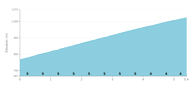
Difficulty breakdown: This 5.4 km climb with 255 m of elevation gain has a steady gradient, around 5% from km 0.0 to km 4.0, then 4% from km 4.0 to km 5.4. No truly steep section is flagged, so the difficulty comes mostly from the duration and the constant effort, with no real moment to recover. With an average gradient of 4.7%, this is a Category 3 climb that's doable but demanding, and it punishes riders who go out too hard.
Tips for managing your effort:
1. Pace yourself from km 0.0 to 0.5. Find a sustainable rhythm from the first metres at 5%, because going out too hard will cost you dearly over the following kilometres.
2. Manage your gearing from km 0.0 to km 4.0. Keep a steady cadence, around 80 to 90 rpm, choosing a gear that spares your legs on this 5% section.
3. Build up gradually from km 4.0 to km 5.4. The gradient eases to 4%, so you can gradually raise your intensity and finish strong to the summit.
Reviews of Grajnár are mixed, and the complaints come up often. Several people describe the road running alongside the cross-country ski trail as really beat up, since cars and sleds use it. Some mention a surface covered in ice and rocks, and two of them clearly advise against riding it.
Those who came in winter to ski paint a different picture. The cross-country trails are well maintained, the views are great, and you can link up the different loops. The site has five routes of varying length and difficulty, with a handy car park. One person finds it ideal for a snowy stroll, another for learning to ski, and another compares the place to a winter fairytale.
On the bike side, reports are thinner on the ground but detailed. One rider went up twice last year: once with his son, from Nálepkovo through Hnilec to the Súľov pass, and once solo, from Fintice to Dedinky and back. Another person flags a nice road towards Veľká Knola. These rides seem to have been done off the ski trails.
As for the vibe, reviews mostly talk about calm and nature. The place is described as a spot to unwind, in summer as well as winter, and good for families. One person spent part of their youth there. Several say they want to come back in summer to see the landscapes without snow, which suggests the warm-season riding conditions still need checking.
5.4 km • 255 m D+
VAM: average climbing speed, based on elevation gain


Join thousands of cycling fans! Plan your rides, record your performance, track your progress and discover the finest climbs.
Live climb profile to pace your effort all the way to the top.

