
Súľová is a climb of 9.5 kilometers (category 3). The climb finishes at 908 m above sea level. It is located in Gemerská Poloma, Košický kraj, Slovensko. The average gradient is 4.5% with a maximum of 6.4%. The climb has 422 meters of elevation gain.
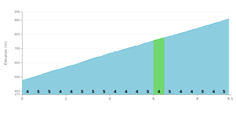
Difficulty analysis: Súľová is a Category 3 climb covering 9.5 km with 422 m of elevation gain, at an average gradient of 4.5%. The profile is very consistent: the gradient hovers between 4% and 6% on every kilometre, with no real respite. The hardest section is between km 2.5 and 3.0 at 6%, and the final stretch from km 8.0 to 9.5 stays honest at 5%. It's a demanding climb, both for its length and its relentless consistency.
Pacing tips:
1. Find a steady rhythm from the start: over the first half-kilometre at 4%, stay in a controlled effort zone so you don't blow up before the heart of the climb.
2. Prepare for the 6% section: between km 2.5 and 3.0, shift to an easier gear and keep a high cadence rather than mashing the pedals.
3. Manage the final part: from km 8.0 to 9.5, at 5%, keep drinking and eating regularly, then gradually pick up the pace over the last half-kilometre.
Those who have ridden it describe first a quiet pass, with nature they say is well preserved. One rider notes that there are few people and the place stays calm. Another points out there are great riding options in the surrounding area.
The road itself is full of tight switchbacks. One witness describes it as a climb followed by a descent to take carefully, and that's where people tend to stop to catch their breath in between. Another talks about the beauty of the scenery and adds that motorbikes, enduro bikes in particular, also use these roads.
As for facilities, the lack is clearly mentioned: no kiosk, no feed station and no toilets. You need to arrive with water and food. Parking is in a car park, and several hiking trails start from there, including the red-marked trail, the E8.
For walkers, one witness hiked from the village of Hnilec up to the pass. There's no particular view along the way, but he found the walk accessible, even for people who aren't very fit. For cyclists, the climb is still a real grind that demands some stamina, and those who have done it describe it as a good opportunity to recover before heading back out.
9.5 km • 422 m D+
VAM: average climbing speed, based on elevation gain


Join thousands of cycling fans! Plan your rides, record your performance, track your progress and discover the finest climbs.
Live climb profile to pace your effort all the way to the top.

